
Figure 1. Study Area Location
Landslides pose a great risk to life and property, therefore landslide susceptibility assessment is of vital importance, especially, in the hilly terrain. The key objective of this study is to generate a landslide susceptibility map through integrating weightages of different categories of the landslide causative factors derived from Statistical Information Value Model (SIVM) under Geographic Information Systems (GIS) environment. Several causative factors, such as slope, slope aspect, geology, drainage proximity, structural feature proximity, Landu Use/ Land Cover (LU/LC), NDVI, curvature, topographic wetness index, stream power index, road proximity, and relative relief were identified in this study area resulting in slope failures to a great extent. The existing landslides were mapped using remotely sensed data and field survey which were then divided into 70% (model training, i.e. calibration) and 30% (model testing, i.e. validation) data sets. Finally, the Landslide susceptibility map derived from statistical information value model has been divided into five equal classes, namely Very Low, Low, Moderate, High, and Very High. The accuracy of the model was evaluated using Receiver Operation Characteristic (ROC) curve, which resulted in 0.86 areas under curve. The area under curve figure reflects that the prediction accuracy of model is 86% and the results obtained will be useful for the policymakers in the study area for the generation of key plans and decision-making tasks.
Landslide is a complex geological phenomena causing huge amount of loss to the life and property. It is termed as hazardous when it occurs over a sparsely populated area; so that the amount of damage done by the landslide is very less. It is termed as a disaster when the damage done by the landslides is comparatively higher than the latter part. Landslides are caused due to the slope instability, which are devoid of vegetation in which the huge volume of rock is dislocated and moves down slope under the influence of gravity (Carrara et al., 1991). GIS techniques and statistical models in evaluating landslide hazard gravity and inclination angle is considered as important parameters for the landslides. It consists of two tangential components such as tangent components, and normal component in which the gravitational force acts orthogonally towards the rock and in the latter part it acts parallel to the piece of rock. Landslides are the events of hazard causing huge amount of loss not only to life and property, but economy loss as well. Landslides can be categorized in many types depending upon the size of the materials dislocated thus making it more a kind of complex phenomena, such as topples, rock fall, spreads, debris flow, mud flow, soil creeping, and transitional slides. Due to these complexities, there is not a single method to map hazard zones and risk evaluation.
The state of Uttarakhand, i.e. the Kumaun Himalaya has front towards enormous losses, including death and missing of thousands due to cloud bursts and landslides in and around Almora district. This pushes for instant answer and solid action. It is necessary to understand the landslide process, to study the factors that create instability, analyze the hazard, and predict the future landslides to prevent the damages caused by this lifethreatening hazard. The reasons for which the respected area was chosen for the study are presence of South Almora Thrust, Ramgarh Thrust along with joints and folds, which is a symbolic of shear zones resulting in slope failures. Presence of sparse vegetation and barren land results in different types of weathering. High Dip angles of rocks and slope concavities and contact zone of sedimentary rocks with crystalline having low shear strength results in slope failures and most importantly due human activities, i.e. construction of roads, deforestation for the establishment of buildings, etc.
The advent of the technology of remote sensing and geoinformation have helped to control this situation to a great extent. The advantage of remotely sensed data is that to get temporal and multi spectral data of different satellites such as a spatial resolution ranging from 61 cm to 30 m of IKONOS and LANDSAT, respectively, Geo Eye 0.5 m CARTOSAT 2.5 m and many more along with the elevation models of ASTER 30 m and SRTM (Shuttle Radar Topographic Mission) 90 m resolutions, which have enabled the researchers to perform terrain modelling of the study area. Earlier traditional stereoscopes were used to identify landslides by getting the vertical aerial photos of that area and mapping of the landslides (Adhikari, 2011) and hazardous terrain using remote sensing. Earlier methods (Ahmad, 2015) were based on field surveys and present landslide inventory of landslides, which does not have the quality predicted accuracy at present medium scale map for the landslide hazard zonation used (1:25000 to 1:50000) and provides a qualitative map based on heuristics, which lacks the predicted accuracy therefore data driven methodology is considered to be the best methodology, which considers the pixel value of the raster data. There are number of geo spatial and statistical methodologies, which have been used by different researches, such as fuzzy logic integration with likelihood ratio method (Chung and Fabbri, 2003). Validation of spatial prediction models were carried out for landslide hazard mapping, discriminate analysis and index of entropy method Bayesian logistic regression or weights of evidence, Logistic regression (Pradhan et al., 2014; Das et al., 2011; Ghosh, 2011; Sarkar et al., 2008). Landslide susceptibility assessment and factor effect analysis among all these methods can be best classified as “what” are the chances of the occurrences of landslide or an event and “when”, but the magnitude can be estimated by using the temporal data of landslides and sizes by using probability methods such, as Poisson and Binomial Model Validation. In this current study, statistical method can be used with the help of the factors associated with the occurrence of landslides. These factors or parameters are then combined with landslide inventories for the prediction of future landslide occurrences. In statistical method, evaluation can be done by two methods, such as multivariate and bivariate method. The difference between these two methods is that, in the former method all the parameters are treated together to obtain the resultant map and in the latter, each parameter is separately combined with the landslide inventory map. For the current study, the latter method has been used. Again, within the bivariate statistical method the technique named as statistical information value model have been used due to its simplicity and reliability. As per the above arguments, the aim of this study is to find out a landslide susceptibility map using a robust statistical method.
The study area lies in Almora district of Uttarakhand state and covers a total area of approximately 230 km². The study area is connected with famous hill stations, such as Pithoragarh and Nainital, which are key places of tourism. The topography of the study area is shown in Figure 1 and this area is highly rugged and dissected with steep gradient. The elevation of the study area varies between 794 m to 2475 m and is drained by Kosi River. The area consists of several thrust and faults, such as Ramgarh thrust and North Almora thrust, which has made the study area tectonically active. The Ramgarh thrust overrides the central crystalline with the lower Himalayan sequence mainly consisting of metamorphic and sedimentary rocks of Ramgarh and Natghat formation. The Garampani fault is a North - South trending 10 km fault, which is an offshoot of Ramgarh thrust is present in the study area. The South Almora thrust is a contact zone of rocks of Almora group and Ramgarh of low grade rocks.

Figure 1. Study Area Location
In this study, different types of data are used (Table 1).
Digital Elevation Model (DEM): DEM of CARTOSAT having a spatial resolution of 30 m has been used for generating terrain and hydrological layer. IRS LISS-III image has been used for the extraction of Landuse/ Landcover (LU/LC) layer by creating standard False Colour Composite (FCC) imager of 23.5 m resolution. Geological survey of India maps of 1:250000 scale has been used for the extraction of geological information and recent google earth imager has been used for the digitization of landslides in the study area.
Figure 7. Slope of Study Area

Figure 4. Profile Curvature

Figure 2. Aspect of Study Area

Figure 3. Relative Relief

Figure 5. Drainage Proximity
The hydro-geological parameters such as Topographic Wetness Index (Figure 6) and Stream Power Index (Figure 8) were derived using slope and flow accumulation of the study area.


Figure 6. Topographic Wetness Index
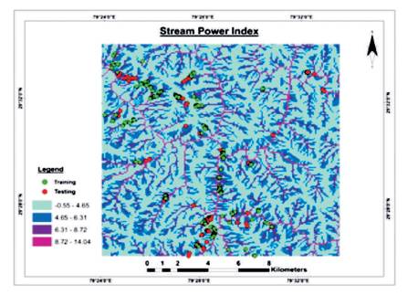
Figure 8. SPI of Study Area
where, Ln = natural logarithm; and
CA= Flow accumulation;
Topographic Wetness index is the upslope catchment area, where slope is in radians which resembles the soil moisture in a particular area and Stream Power index is the erosive power of the stream. Values are generally high where there is high flow accumulation on very gentle slopes in TWI indicating high water seepage and increase in the soil moisture content, steep slopes having high flow accumulation resembles high erosive power of streams having potential to cause landslides. Structural features of the study area consists of two major thrusts, such as Ramgarh and North Almora thrust and several irregular fault and folds. These structural features (Figure 9) were extracted from geological survey of India map, which cause landslides in this area. It has been widely identified that geology (Figure 10) greatly influences the occurrence of landslides.
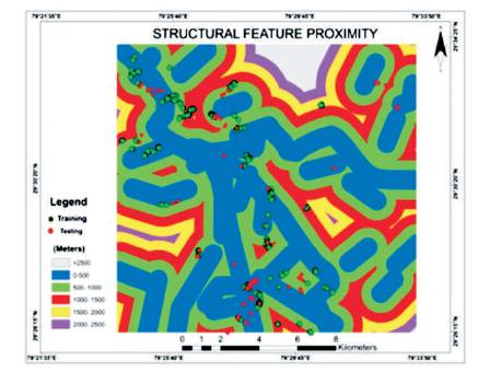
Figure 9. Structural Features of Study Area
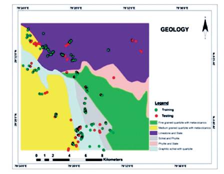
Figure 10. Geology of Study Area
This parameter is derived from LISS-III data through supervised classification and it is seen that the study area (Figure 12) comprises of variable vegetation spread starting from very high to low. In NDVI (Figure 11), it is seen that the study area comprises of variable vegetation spread starting from very high to low. NDVI is considered as a good proxy for vegetation biomass estimation. Therefore, NDVI was included to assess the impact of vegetation biomass on landslides road proximity was constructed in the form of buffer of road layer. The roads were digitized from the Google earth satellite image. Figure 13 shows road networks of study area.
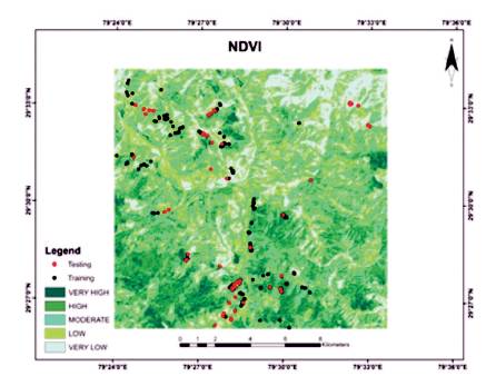
Figure 11. NDVI of Study Area
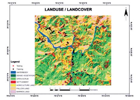
Figure 12. LU/LC of Study Area
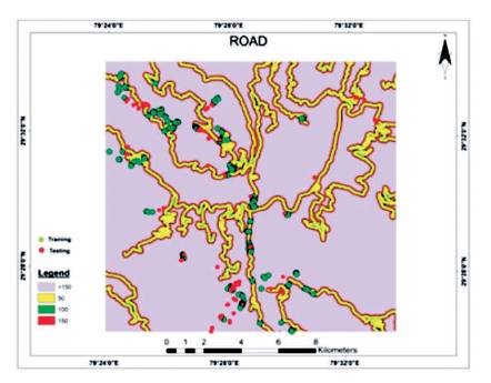
Figure 13. Road of Study Area
The landslide susceptibility map has been generated by using Statistical Information Value Model (SIVM) and the efficiency was tested using statistical techniques. To accomplish this task, landslides were digitized using recent Google earth images. The digitized landslides were divided into 70% training (Figure 14) and 30% testing (Figure 15) samples by random sampling method and a thematic layer was created by reclassifying the landslide distribution in the study area into landslide –'1' and non- Landslide – '0' pixels for both calibration and validation.
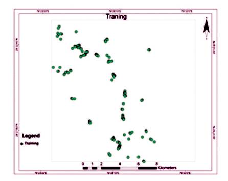
Figure 14. Training Data
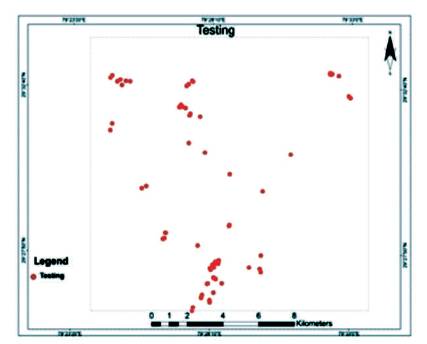
Figure 15. Testing Data
SIVM is a probabilistic modelling of landslide susceptibility based on the conditional probability and information value generated from each class of the geoenvironmental factors. In other words, it deals with the correlation of landslides with the influential factors and it is considered as one of the important methods for the landslide susceptibility and used by several researchers such as Yin (1988); GIS based spatial data analysis was also used for landslide susceptibility mapping in East Sikkim (Sarkar and Kanungo, 2004; Long, 2008; Jaafari et al., 2014). This method computes the conditional probability and the prior probability of landslides in each class of the thematic layer. If the statistical information value is negative, it represents the negative correlation of landslides with that class of the geo environmental factor, whereas positive value indicates stronger correlation of landslides with each class.
As given by Yin is statistical prediction model for slope instability of metamorphosed rocks (Yin,1988), information value 'Ii' for the 'i' geo environmental factor can be expressed as,

where,
N = total number of pixels of the I class of the geo environmental factor;
S = total number of pixels having landslides which was denoted by '1';
S = total number of pixels in the i class of the factor which has landslides; and
N = total number of pixels in the i factor affecting i landslides.
Now the information value in a pixel J is denoted by,

The reclassified layers of landslides were resampled into 5*5 pixel size. The important parameters affecting landslides were identified as Slope, Slope Aspect, Road Proximity, Thrust Proximity, Land Use Land Cover, Geology, Topographic Wetness Index and Stream Power Index, NDVI, Drainage Proximity, Relative Relief. The parameters were also resampled into 5 x 5 m pixel size to match the grid size of training and testing thematic layers of landslides. Each thematic layers were crossed with landslide training layer and pixel count in each sub categories was used to create statistical information value model for the study area. The derived weightages from the model were used to reclassify the thematic layers and were added up to get the landslide susceptibility index. The index was classified into five susceptible zones, such as very low, low, moderate, high, and very high. Finally the accuracy of the model with respect to the testing landslide layer was tested using Receiver Operation Characteristic (ROC) curve as explained below.
According to Guzzetti et al. (1999), the map validation is the core part of the landslide susceptibility mapping because the aim of the landslide susceptibility models is the spatial prediction of the landslide, therefore if the model is not statistically validated then it will be of no use. Many researchers such as Chung and Fabbri (2003); Chalkias et al. (2014); Devkota et al. (2013); Mancini et al. (2010) have validated spatial prediction models for landslide hazard mapping. Guzzetti et al. (1999) have performed the spatial prediction of landslides through area under curve statistics. Therefore, validation of the SIVM method was carried out using ROC curve. It represents the cumulative distribution of the binary variable against the output values. It represents the true positive rates known as sensitivity V , and the false positive s rates are as known as specificity. Landslide susceptibility mapping using index entropy and conditional probability model (Pourghasemi et al., 2012) can be done according to the cut-off value or the threshold provided in the table. It plots the cumulative distribution of the false alarm probability on the y-axis and the detected probability of the variable on the x axis.
According to the model, it reflected the highest correlation of landslides within 500-1000 m of Thrust and Fault Proximity (0.38). The correlation became negative as the distance from the fault and thrust increased. Slopes having angle of 35- 55° and Southeast direction are more vulnerable to landslides in this study area as the information value of slope in this category is 2.27 and for the aspect it was 0.68. The hydrological indices such as Topographic Wetness Index (TWI), 13.26-16.98 class is also an important factor affecting landslides, which has generated a value of 0.37 resembling a strong correlation of sedimentary rocks and moisture content in the terrain as rocks are showing a positive indication of chemical weathering. Standardized Precipitation Index (SPI) class 8.72-14.04 was assigned a weight of 0.54 indicating the dependency of erosive power of stream and landslides. Roads proximity (0 – 50 m) was assigned 0.78 value by the model, which is lesser than the other factors indicating a positive but least dependency of landslides on roads proximity parameter. This finding is quite contrasting to the expectation of otherwise; however, this can be attributed to the fact that human interferences through road construction are quite minimum. The dissected hills and denudational hills have value less than unity but positive thereby reflecting less dependency of landslides on it. Amongst the geological categories, Limestone and Slate (0.68) is vulnerable for the incidence of landslides followed by Barren land (2.07) and Agriculture land (0.18). It can therefore be said that landslides in the region are driven by the geological structures more than anything else. Final map of landslide hazard zonation is ready using Statistical Information Value Model as in Figure16.
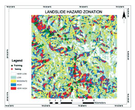
Figure 16. Landslide Susceptibility Map
Using the Statistical Information Value Model, the result is set out in Table 2.
SIVM has 86.27% accuracy, therefore the model can be recommended in landslide prediction mapping. The model has an area under curve of more than 0.5, which is the cut-off value of the hypothesis testing. Therefore null hypothesis is rejected and alternate hypothesis can be assumed.
The factors affecting landslides were identified, such as Slope, Slope aspect, Thrust and Fault Proximity, LandUse/LandCover (LU/LC), TWI, SPI, Geology, Roads Proximity, Relative Relief, NDVI, Profile Curvature, Drainage Proximity by using remotely sensed data and GIS techniques. Statistical Information Value Model (SIVM) was used for making a landslide susceptibility map. The landslide inventories were divided into testing and training samples for model making and validation purpose. The Statistical Information Value Model showed 86.27% accuracy by using ROC curve as shown in Figure 17.
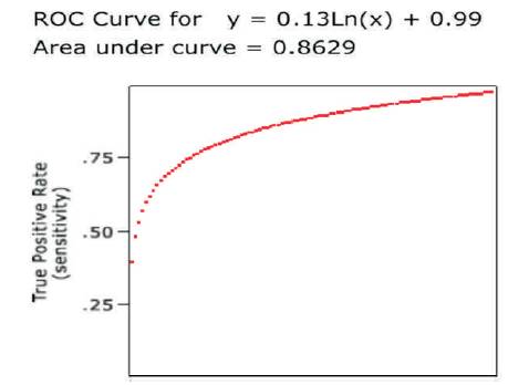
Figure 17. ROC Curve
The study of the area and working on the research work brought some interesting points under notice. The area is obviously affected by both man-made and natural activities. But with the knowledge and correct measures taken, the man-made activities can be controlled and the natural activities can be dealt with by making the people aware. Some of the man-made activities that are catastrophically affecting the lands are continuous construction work, deforestation, blasting for road construction (increased in the study area in the recent times), slope cutting, etc. These activities are recommended to be taken care of immediately. Blasting opens the cracks or joints of the fragile rocks and encourages slope failure. Hence this should be banned. Less artificial works and more plantations have always been the best solution for our environment. Improvement of surface and sub-surface drainage is highly recommended as it will increase stability of the susceptible zones in return.
The soil or rock or both at the head of a landslide is the most sensitive part of the land. Hence it is recommended that this part should be excavated so that it slows down the landslide by decreasing the driving pressure.
Another measure that can be taken to increase the resistivity of the area is embankment fill over the toe of the landslide to provide resistance to sliding forward. Heavy duty fences, concrete catch walls, or wire mesh are very useful in securing a slope from landslide and also from rock fall. Hence these also must be worked on. Above all, the most important measure that should be taken is spreading as much awareness as possible among the people through various training modules, such as workshops, radio, and news and of course more such projects that bring the issue to the society's notice.
This project was done by the authors for the completion of rd their 3 semester examination, 2016 in SSJ Campus, Almora, Kumaun University