Abstract
Flying Ad-hoc Networks (FANETs) have been employed in modern warfare for monitoring and reconnaissance to produce a healthy living environment for wildlife through multiple Unmanned Aerial Vehicles (UAVs). FANETs allow multiple UAVs to communicate in 3D space to establish an ad-hoc network. FANETs applications, among others, can deliver cost-effective services to help future wildlife. However, adopting FANET's technology in wildlife monitoring is difficult due to its challenges in mobility, data routing, energy, and security considerations. Therefore, this paper aims to look at FANET's possible applications in wildlife Monitoring and the implications and issues that come with them.
Keywords:
- Flying Ad-hoc Networks
- Wildlife monitoring
- Unmanned Aerial Vehicle
- High Mobility
- Energy Consumption
Introduction
In recent years, methods for estimating the absolute abundance of wildlife population have drawn much interest. However, wildlife biologists have recently wished to monitor animal populations at extensive scales. There have long been attempts to precisely count the number of wildlife creatures. Animals may become frightened by surveillance systems and attack surveillance equipment and personnel, disrupting surveillance operations and costing time and money. Unmanned Aerial Vehicle (UAV)-assisted data collection is not a new concept and has been used in various mobile ad hoc networks by imitating wildlife animal foraging and using a UAV that makes regular trips across the field to collect data from them. The Unmanned Aerial Vehicle (UAV) can collect data not only from the current node it is communicating with but also from other nodes that this node has come into contact with. The different types of UAVs employed in various Flying Ad-hoc Networks (FANET) scenarios can be classified based on such different factors as UAV size, weight, range, endurance, altitude, application, flying mechanism, ownership, airspace class, level of control (autonomy), and type of engine. Recently, several studies have shown the importance of FANETs by investigating the integration of FANETs on UAVs with different technologies.
1. Flying Ad-hoc Networks
Flying Ad-hoc Networks (FANETs) are such a network that consists of a group of small UAVs connected in an ad-hoc manner that are integrated into a team to achieve high-level goals. Mobility, lack of central control, self-organizing, and ad-hoc nature between the UAVs are the main features of FANETs, which could expand connectivity and extend the communication range in infrastructure-less areas. On the one hand, in cases of catastrophic situations when ordinary communication infrastructure is not available, FANETs can be used to provide a rapidly deployable, flexible, self-configurable, and relatively low-cost network. On the other hand, connecting multiple UAVs in an ad-hoc network is a big challenge. The advent of Flying Ad Hoc Networks (FANETs) has opened an opportunity to create new added-value services. Even though it is clear that these networks share common features with their predecessors, like mobile ad hoc networks and vehicular ad hoc networks, there are several unique characteristics that make FANETs different. These distinctive features impose a series of guidelines to be considered for its successful deployment. Particularly, the use of FANETs for telecommunication services presents demanding challenges in terms of quality of service, energy efficiency, scalability, and adaptability. The proper use of models in research activities will undoubtedly assist in solving those challenges. By evaluating the influence that the Unmanned Aerial Vehicles (UAV) may have on the on-board or embedded communication devices.
2. Unmanned Aerial Vehicle
Rapid technological advances in electronic, sensor, and communication technologies make it possible to create Unmanned Aerial Vehicle (UAV) systems that can fly autonomously or remotely without human personnel. Because of their versatility, flexibility, ease of installation, and low operating costs. UAVs promise new ways for both military and civilian applications, such as rescue operations (Parihar & Chakraborty, 2022), border surveillance (Agrawal et al., 2022), wildfire management (Srivastava & Prakash, 2021), relay networks (Kakamoukas et al., 2022), on-board health monitoring (Mittal et al.,2022), and traffic management (Khan et al., 2017).
However, one small UAV's capacity is insufficient. A system with several UAVs can be more effective than one tiny UAV (Mohsan et al., 2022). Flying Ad-Hoc Networks (FANETs) are a type of network consisting of a group of small UAVs connected ad-hoc and working together to achieve high-level goals via UAV-to-UAV (U2U) and UAV-to infrastructure (U2I) links (Oubbati et al., 2017). UAVs, also known as unmanned aerial vehicles, are used for various tasks. These gadgets were initially controlled manually and remotely. Nevertheless, Artificial Intelligence (AI) and Machine Learning (ML) approaches are frequently included in UAVs, automating some or all tasks (Kumar et al., 2022). Vast volumes of data are collected when more UAVs fly into the skies to survey the Earth's surface and map the surroundings (Kumar & Raw, 2018a). Mobility, lack of centralized control, self-organization, and the ad-hoc nature of UAVs are the significant features of FANETs, which increase connectivity and communication in places without infrastructure (Ananthi & Jose, 2021; (Bekmezci et al., 2013; Kumar & Bansal, 2020;(Kumar et al., 2020a;). UAVs quickly transform the wildlife and conservation industries in FANETs (Kabir & Lee, 2021). They have the potential to revolutionize spatial ecology and conservation. Observing species, populations, and habitats is at the heart of conservation.
The rest of the paper is organized as follows. The third section presents some potential applications of FANETs for wildlife monitoring. The fourth section discusses the issues and challenges of FANETs for wildlife monitoring. The fifth section discusses the findings of this paper. Finally, the sixth section separately covers the conclusion and future scopes.
3. Literature Survey
With its correctness proof and fault handling capabilities, Parihar and Chakraborty (2022) present a novel token-based K mutual exclusion algorithm as a mutual exclusion algorithm for flying network-multi UAVs. To improve overall throughput as compared to single-UAV FANET, our approach works in a multi-resource-occupied flying environment and allows k duplicated resources mounted on available UAVs that facilitate processes to invoke at least k of their critical sections simultaneously. This solution is also fault-tolerant to UAV failure in the system, whereas in single-UAV FANET, this is considered a failure of the entire system.
Agrawal et al. (2022) proposed a novel mobility model for military operations in sparse FANETs. It addresses the issue of sparse networks as well as implementing the proposed work in the simulator in three-dimensional space. The proposed UAV-Sink enabled Mobility Model (US-MM) improves network performance without limiting UAV mobility, which is critical in military operations.
Srivastava and Prakash (2021) depict a comprehensive survey relating FANET and critical points regarding it, ranging from the categorization the architecture types of possible communication numerous mobility models, constraints characteristics and design of FANET, routing protocol, and routing topology. It further presents open issues and challenges in FANET relating to essential parameters and research. It endeavored to store all the recommendations to encourage the researchers to function in this particular area and in the same class of network.
Kakamoukas et al.(2022) review of Flying Ad-Hoc Network (FANET) routing protocols is performed, where their different strategies and routing techniques are thoroughly described. A classification of UAV deployment in agriculture is conducted, resulting in six different applications namely crop scouting, crop surveying and mapping, crop insurance, cultivation planning and management, the application of chemicals, and geo-fencing. Finally, a theoretical analysis is performed that suggests which routing protocol can better serve each agriculture application, depending on the mobility models and the agricultural-specific application requirements.
Mittal et al. (2022) investigate the problem of generating a multi-hop routing structure for data transmission to maximize the overall network throughput of a flying ad-hoc network using UAVs. Specifically, propose an optimization problem to jointly select a communication link and its transmission power so that the overall network throughput for a given total power budget is maximized. The problem is non-convex over selected metrics, thus making it an NP-hard problem. Without loss of generality, consider the Dijkstra-based shortest-path tree as a routing structure, thereby converting the original problem into a solvable convex problem over the transmission link metric.
4. Applications of FANETs
FANETs are used in many areas, like military regions, for security purposes and they are used in agricultural management to detect the quality of crop growth and other issues. In addition, FANETs can replace intensive labor and complicated observational infrastructure in roadway traffic monitoring and detecting traffic crashes. It is also used for capturing the best shots of every moment. The applications discuss FANETs related to wildlife monitoring. Figure 1 shows the network diagram for the FANETs-enabled wildlife monitoring architecture.
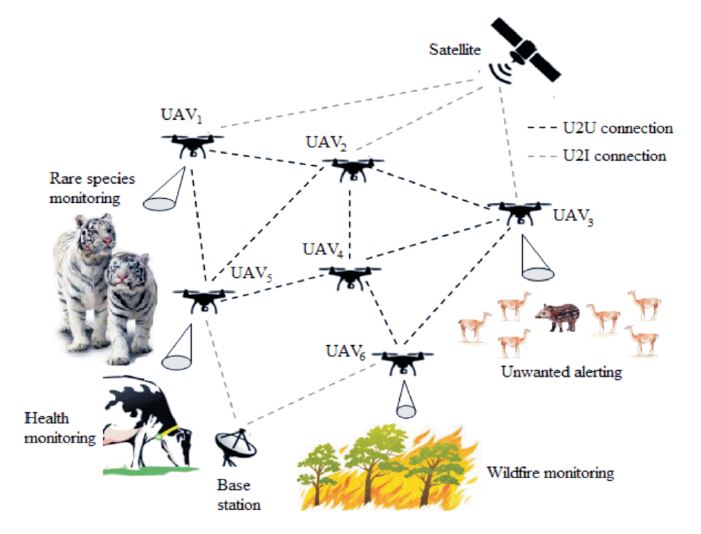
Figure 1. FANETs Enabled Wildlife Monitoring Architecture.
4.1 Weather Monitoring for Rare Species
Wildlife monitoring for rare species Using FANETs is effective in a variety of ways. For wildlife monitoring, there are various factors that one should keep in mind. First, weather changes are followed by a suitable environment. The weather should be tailored to the needs of the species. Weather is an important factor for the growth of species. Using FANETs, precisely adjust the monitor to the weather. A rare species needs weather monitoring frequently. Some species need warm conditions, and some need proper moisture in the atmosphere. Global warming also affects the living conditions in India for animals and rare species. Change in the bodies of species is monitored 24 hours a day, seven days a week using FANETs. The root cause of the change in weather can also be detected. A rare species needs weather monitoring frequently recording the temperature (in Celsius), relative humidity (%), and wind speed. A change in weather can affect the health of species. Monitoring rare species using technologies like FANETs can save various rare species for a long time and also lead to an increase in their numbers.
4.2 Surveillance for Wildlife Activity
Using this application, you can keep track of the wildlife population and their activities. Animal migration and movement can be studied throughout the year. Seasonal health concerns or potential threats to birds and wildlife are also investigated. FANETs use thermal and long-range focal-point cameras to keep an eye on wildlife throughout the day and at night. Furthermore, motion sensors and an accelerometer are used to calculate and record vehicle movement as well as the direction of wildlife animals and/or birds. FANETs have cameras, laser lights, Global Positioning System (GPS) tracking, altimeters, and other features that make them ideal for wildlife monitoring.
4.3 Act as Invisible Human Eye
Apart from data collection and mapping, illegal hunting, poaching, and many more are commonplace. To resolve these issues, drone surveillance is an effective way to keep an eye out for poaching for wildlife monitoring purposes. They can access places that are difficult for humans to enter and are cost-effective. It offers a bird’s eye view of forests and wildlife, as well as information, photos, and data that would otherwise be difficult and expensive to obtain. Furthermore, wildlife officials can use FANETs to monitor wayward wild animals that enter populated areas. UAVs can navigate through dense woodland while utilizing artificial intelligence and thermal imagery to find a stray animal. A practical method of reducing conflict between people and wildlife is UAV surveillance. In FANETs, UAVs with thermal imaging capabilities can interpret heat signatures and spot forest fires early on. With prompt notice, timely detection of wildfires can prevent them from spreading.
In addition to keeping a watch, UAVs may locate any sick or injured animals or birds, aiding authorities in taking immediate action (Hodgson et al., 2016). If FANETs are employed wisely, UAVs can be used for various purposes, including law enforcement, search and rescue operations, and more (Šimek et al., 2017). UAV-enabled FANETs can also be used to monitor and track a variety of elusive and wary creatures, which are incredibly elusive to the human eye and hard to spot in their natural habitat. UAVs can acquire exotic photos, count animal populations, monitor wildlife, plant reforestation, and track illicit activity. FANETs for forests and wildlife give us a better tomorrow by monitoring the health of the forest, encroachments, tree-felling, forest fires, poaching, the condition of water bodies, biodiversity protection, and mangrove conservation (Linchant et al., 2015).
5. FANETs Challenges and Issues
Although UAV technology has made significant strides, FANETs still face several obstacles that could negatively impact the network's performance (Ananthi & Jose, 2022). This show few difficulties relating to FANETs in observing wildlife. However, numerous analysts and experts have suggested various strategies and methods for increasing the use of FANETs, which have unique features including highly mobile UAVs and network topology that frequently changes. FANETs still have several challenges and difficulties.
5.1 High Mobility
Some UAVs are disconnected from the network due to their mobility in three dimensions. This is exacerbated by a lack of control over node movements that change rapidly. As a result, after a specific range, connection has been lost to the UAV during important surveys while volunteering for illegal wildlife activity. That is why it can be challenging to choose suitable mobility models for FANETs (Ullah et al., 2022).
5.2 Energy Consumption
The energy consumption of UAVs in FANETs is one of the most significant barriers to time-consuming operations (Arafat & Moh, 2021).UAVs are frequently battery powered and used for various 3D on-board information distribution jobs (Kumar et al., 2020b), such as tracking animal movements or monitoring wildlife health issues. When UAVs can stay in the air for extended periods in FANETs, their economic impact increases. For example, they can effectively monitor infrastructure while covering a larger area, like a forest, in 3D mapping applications and delivering more information to remote locations. When FANET is used to cover a large area, UAVs must frequently return to the charging station for recharging.
5.3 Frequent Topology Change
The topology changing rapidly is one of the most important factors influencing the effectiveness of information dissemination in FANETs (Wheeb et al., 2021). Each UAV may stray from its original course during some crucial FANETs missions due to dynamic and atmospheric factors such as weather, updating UAVs, fixed barriers (mountains, high-rise buildings), and other things (Mohsan et al., 2022). Where to go next should be determined dynamically. Topology can be changed due to bad weather conditions in the forest. UAVs must cover a large forest area to monitor animals so that topology can change accordingly. UAVs must be monitored 24 hours a day, seven days a week, which necessitates frequent topology changes. High-speed moving nodes in FANETs frequently carry out numerous duties, such as target tracking, reconnaissance and patrol, or search and exploration (Srivastava & Prakash, 2021). The UAV mobility mode, which includes UAV motion speed, direction, and distance, varies when the job does, which causes the network architecture to vary quickly and adversely affects. Due to frequent changes in topology, sometimes it cannot cover the desired area of forest (Rahmani et al.,2022).
5.4 Moving Speed and Direction
The slow data transmission speed of UAV technology, which could be weak, is one of the obstacles to its expansion in precision wildlife monitoring. If data transport is delayed, relevant information may be harmed or suffer during that time. When discussing direction, a UAV pilot could crash into a tree or come into contact with a vulnerable animal if they are operating in an area with many wild animals. Due to the lack of physical and Communication, Navigation, and Surveillance (CNS) infrastructure, as well as how to incorporate UAVs, their handling services, such as maintenance or electric charging, will be required (Kumar et al., 2021a). Finally, for them to fly safely and communicate their positions, CNS infrastructure is required. As a result, for UAVs to interact and cooperate, FANET needs some new strategies and approaches for dynamic direction planning so that it will not interfere with wildlife activity (Kumar et al., 2021b).
5.5 Data Routing Retransmission
Routing is a technique for selecting a path for traffic in a network. Since the network topology is constantly changing, routing during communication is also influenced (Arafat & Moh, 2021). FANET's routing protocols are crucial for distributing information among UAVs and managing all data flow regarding wildlife operations for UAVs and other connected devices (Kumar et al.,2021c). They partially fail in the environment of FANETs because of the fast-moving UAVs and the highly changeable network architecture (Seema et al., 2022). Their retransmission is questionable as they fail to provide the current situation frequently. Critical applications like disaster rescue operations and wildlife behavior depend on the timely and accurate delivery of rescue information. It is essential to create a practical network for UAV communication.
5.6 Security
One of the significant challenges FANET is ensuring the privacy, accessibility, and integrity of information during communication between UAVs. In some FANET applications, very tiny UAVs or mini-UAVs are preferred to address the security issue (Kumar et al., 2022). However, another problem is that they are readily stolen. In a wireless setting compared to a wired system, eaves dropping is substantially simpler than using UAVs, and an entire network may occasionally be under the control of unauthorized parties (hackers). Therefore, it is necessary to find a research-based solution to these problems from the perspective of FANET security (Kumar & Raw, 2018b).
6. Discussion
The key characteristics of FANETs, which could improve connectivity and communication range in areas without infrastructure, include mobility, the absence of centralized control, self-organization, and the ad-hoc nature of UAVs. UAVs quickly changed the way the wildlife and conservation industries appeared in FANETs. They could fundamentally alter spatial ecology and conservation. Species, populations, and habitat observation are at the core of conservation.
The proposed approach can be utilized to transmit emergency information to nearby management systems and collect it for the immediate rescue of wild animals if any causalities occur. The nearby management system records the received data in the emergency-recording database and immediately informs emergency personnel. Furthermore, the outcomes of this research focus on the importance of FANETs and how they play a key role in wildlife monitoring. Aside from that, it is critical to investigate the various applications where FANETs are used in wildlife monitoring. Additionally, discuss some of the major challenges with using FANETs to observe wildlife activity.
Conclusion and Future Scope
FANETs technology will change the world and transform monitoring applications in the coming years due to the vast utilization of UAVs. FANETs incorporate modern technological advancements such as the Internet of Things (IoT), sensors, Artificial Intelligence (AI), Machine Learning (ML), and many more in the fields of military, agriculture, and the commercial sector. Combining these technologies will result in wildlife having a sustainable and tranquil living environment. The systematic application areas of FANETs in wildlife monitoring were presented in this research. However, various unresolved issues and obstacles must be considered with the development and application of FANET's technology for wildlife monitoring. Finally, FANET's technology can have a huge impact and benefit for any country when applied correctly and efficiently.
In the future, police agencies can use FANETs to conduct routine patrols in rural and coastal areas, with diverse flight paths designed to keep a watch on local communities. With the world's population expected to quadruple by 2050, there is a growing interest in innovative, smart city construction. It is necessary to properly incorporate information and communication technology solutions and trends into FANETs while creating smart cities.