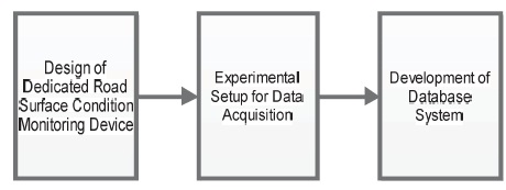
Figure 1. Proposed System Design and Implementation
This paper proposes a road surface condition monitoring device. The design features the use of a programmed accelerometer sensor deployed to respond to vehicular vibrations as a function of the vehicle's acceleration due to gravity (g-force). Furthermore, a database was created and hosted online to store the traces acquired over the different test surfaces. The test results show that the proposed system successfully sensed the utilized road surfaces, and effectively logged the acquired traces into the created database. This device will be beneficial to road maintenance agencies for road surface monitoring, and it can be installed in both manned and unmanned vehicles to enhance road navigation. In addition, the stored traces can be freely accessed and used by researchers working in related areas.
Most poorly constructed and maintained roads are largely characterized by anomalies, such as potholes, rutting, speed-bumps, and pavement cracks. These anomalies are causatives to a number of road traffic accidents leading to the loss of lives and properties (Agbonkhese, et. al., 2013; Kawu, 2016). Often, these anomalies are induced owing to the use of poor quality road construction materials, inadequate drainage systems, and poor road maintenance culture (Bello- Salau, Aibinu, Onwuka, Dukiya, & Onumanyi, 2014). They cause accidents, and negatively impact the economic development of the affected areas.
In conditions where anomalies persist, a new paradigm may be required to curb the rate of induced accidents. One approach from the vehicular point of view is to facilitate vehicles with the capability to sense, characterize and profile road anomalies (Bello-Salau, et. al., 2015, 2016). This will provide early information to drivers warning them about impending anomalies to aid their navigation. In this regard, Smartphone Based Accelerometers (SBAs) have been widely used in the literature (Bello-Salau et al., 2018; Strutu & Popescu, 2014). Their use can be attributed to their quick operational response time, low maintenance cost as well as the ease of processing the measured traces. Essentially, SBAs have been used to detect road anomalies. Nevertheless, a major drawback with deploying SBAs lies in the variance in sensitivity levels associated with different types of SBAs. Different smartphones incorporate different accelerometers, some of which may be poorly developed leading to inaccurate measurements. In the absence of existing standards, it becomes difficult to generalize on the use of SBAs. In addition, the lack of standard databases for storing sensed traces fetters the standardization/research process while poorly aiding road maintenance exercises.
Thus, in this paper, a dedicated road surface condition monitoring device is proposed based on the use of an accelerometer device embedded in a National Instrument (NI) MyRio board. Furthermore, report on the creation of an online database for hosting the acquired road surface condition traces is presented. The results obtained are promising and suggest the possibility for having standardized road surface condition traces across different countries all sensed under the same device condition. The database can be accessed by expert users or researchers working on related problems. Consequently, this paper is noted to have made the following contributions, namely:
This section presents an overview of some specific achievements in the literature that motivated this study. Basically, it is noted that most methods for road surface monitoring are limited by (1) The dependency of the system's performance on the SBA's sensitivity level, and (2) The lack of standard open databases for storing measured traces for free easy access. Such open databases possess the potential to contribute towards enhancing research purposes in this regard. For example, the approaches adopted in (Bello-Salau, et. al., 2018; Douangphachanh & Oneyama, 2014; Strutu & Popescu, 2014; Vittorio, Rosolino, Teresa, Vittoria, & Vincenzo, 2014) resulted in traces that were stored in respective databases. However, these databases were unopened for public access, thus stifling free access to these traces even for research purposes. In addition, the effectiveness of the SBA approachused in (Douangphachanh & Oneyama, 2014; Vittorio et al., 2014; Astarita, Festa, Mongelli, & Tassitani, 2014; Mukherjee & Majhi, 2016) was a function of the quality of the phone make.
A similar approach for road surface condition monitoring based on SBA was proposed in (Astarita et al., 2012). Their approach involved profiling as well as GPS coordinate mapping during their drive test exercise. Similar approaches were proposed in (Aksamit & Szmechta, 2011; Forslöf, 2012; Mednis, Strazdins, Zviedris, Kanonirs, & Selavo, 2011; Seraj, van der Zwaag, Dilo, Luarasi, & Havinga, 2014; Perttunen et al., 2011). Essentially, the performance of these approaches depended on the quality of the SBA used as a function of the phone make. Furthermore, the experimental traces acquired in these works were not made available for free public use.
Some other methods were noted in (Bello-Salau et al., 2016, 2018; Astarita et al., 2014; Li et al., 2017). Despite their complexities, they were noted for their success in accurate trace measurements. Similar approaches were proposed in (Bello-Salau et. al., 2015; Mednis et al., 2011; Mednis, Elsts, & Selavo, 2012; Strazdins, Mednis, Kanonirs, Zviedris, & Selavo, 2011). The results from these works indicated successful trace measurements at the expense of closed access to the measured stored traces. Summarily, it remains essential to develop road surface condition monitoring devices that are void of SBAs. In addition, designing and developing open databases for free and easy access for research and maintenance purposes is worthwhile.
These served as the motivation for the study presented in this paper.
The proposed system was developed in three stages as presented in Figure 1. These stages are the design of the dedicated road surface condition monitoring device, the experimental setup for data acquisition, and the database development stage. Details of each stage are presented in the following subsections.
Figure 1. Proposed System Design and Implementation
An accelerometer-embedded device (National Instrument (NI) MyRio board to be specific) was programmed using LABVIEW software. This was done to measure the vehicle's vibration relative to its acceleration due to gravity (g-force). The three-dimensional spatial axis of the device was considered for measurement. Each axis monitors specific responses of the vehicle. For example, the turning (left and right) motion of the vehicle, the slope of the road and the upward and downward movement of the vehicle correspond to the traces displayed on the x, y, and z-axis of the accelerometer, respectively. Each axis, been channels on the myRio board were opened and configured based on a preset sampling rate using the LABVIEW software. The value of the preset sampling rate fs used for measurement at every T second was computed using equation (1). The sampled traces along each dimension (x, y, and z-axis) were then passed through two Lowpass inverse Chebyshev filters of order 3 with a cutoff frequency of 100 Hz. The filter's transfer function H used to I, n predict the device's output response is expressed in equation (2) (Schaumann & Valkenburg, 2001). These filters were cascaded in series such that the output of the first filter served as the input to the second filter. The choice of this filter was based on its ability to produce flat magnitude pass band responses and steep attenuation rates, which were desired. The preprocessing stage was carried out in order to filter out noisy components from the vehicle acceleration trace acquired via each accelerometer channel. The filtered traces from each channel were then merged together in the LABVIEW environment to display the tri-axial traces as a single waveform. The sample index as well as the corresponding measured traces were exported as Microsoft Excel worksheets and later analyzed. The analogue input pin of the NI Myrio device was used to connect a Global Positioning System (GPS) to the device via the Arduino Integrated Development Environment (IDE). This was done to log the corresponding coordinates associated with each data point in the channel (that is, the x, y, and z axis). A flowchart of the design process as carried out using the LABVIEW software is presented in Figure 2. The entire block diagram of the system is shown in Figure 3. The process flow of the GPS system is presented in Figure 4. The GPS was first initialized to log and record the corresponding longitude and latitude coordinates of each sensed data point. Then these coordinates were saved on a memory card and used to match the measured traces to their physical location. This ensured that the physical locations, where the road surface traces were acquired could be easily tracked.

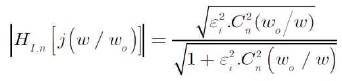
where, w is the normalized passband edge frequency, wo is the passband edge frequency, n is the order of approximation function for the filter, Cn w is the Chebyshev polynomial of first kind of degree n, and astop is the of the passband. The inverse passband gain adjustment factor ei is expressed in (3). This enables the system to produce a more stable output.
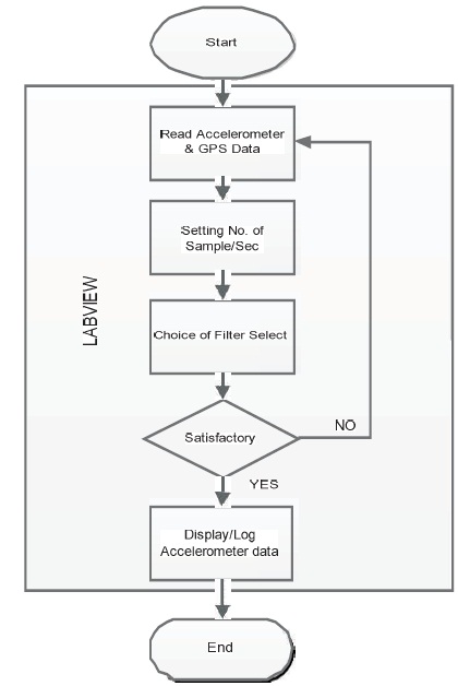
Figure 2. Design of the Proposed Dedicated Road Surface Monitoring Device
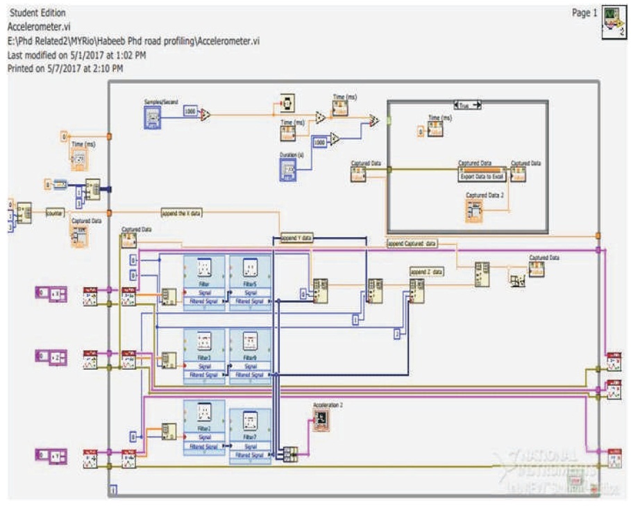
Figure 3. LABVIEW Block Diagram VI of the Designed System
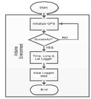
Figure 4. Developed GPS Coordinate Acquisition System
The sampling rate of the developed dedicated accelerometer embedded device was set to 20 Hz based on the value computed using equation (1). This was done in LABVIEW via the front panel with a screenshot provided in Figure 5. The flexibility of allowing users to set the required sampling rate was introduced for ease of data processing, analysis, and localization of road anomalies. Once developed, the device was placed on the dashboard of a car and connected to a Laptop during the data acquisition phase (see Figure 6). The choice of the device's placement in the car was considered optimal following the report in (Bello-Salau et. al., 2018; Mukherjee & Majhi, 2016; Strazdins et al., 2011). Two test roads were considered during the drive test namely,
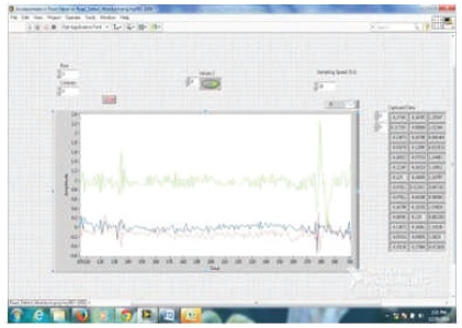
Figure 5. Screenshot of LABVIEW Front Panel Vi during Data Acquisition
The traces acquired during the drive test were saved in Microsoft Excel format and subsequently uploaded to the database.
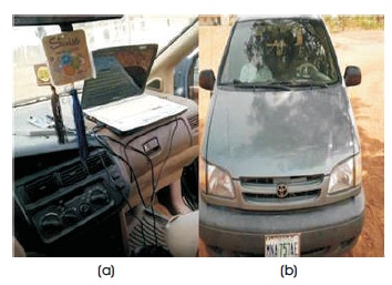
Figure 6. (a) Experimental Setup (b) Vehicle used
In this section, the design process for the database creation, online hosting, and the data storage is presented.
2.3.1 Creating the Database using MySQL
An open source cross platform, web server solution stack package called XAMPP control panel was used for the creation exercise. MySQL and Apache were executed from the control panel of the XAMPP software. A browser (Mozilla Firefox to be specific) was used to launch the domain “localhost/phpmyadmin/” via the browser's address bar. The database was created and named "Accelerometer Readings Locations". The created database was displayed on the phpmyadmin interface indicating that the database was successfully created.
2.3.2 Creating Table (fields) for the Accelerometer Readings Locations Database
The created database "Accelerometer Readings Locations" was launched from the phpmyadmin interface. The name "Gidan-Kwano" was assigned and the required table columns (fields) of six was created. Each field was named as follows: (1) Serial number (S/N) (2) X-Axis (3) Y- Axis (4) Z-Axis (5) Longitude, and (6) Latitude. The column data type for each field was assigned. The integer data format type was assigned for S/No and floating for all other fields. A screenshot of the structure of the created “Accelerometer Readings Locations” database fields is shown in Figure 7.
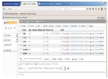
Figure 7. Screenshot of the Accelerometer Readings Locations Database Fields Structure
2.3.3 Importing the Saved Sensed Road Anomalies Data in Excel to the Developed Database
The data structure in CSV format contained the same number of columns (fields) with the created database (Accelerometer Readings Locations). The created table (Gidan-Kwano) on the phpmyadmin interface was initialized for importing the CSV files. The Go button was launched to import the saved sensed road anomalies data in Excel file into the created Accelerometer Readings Locations database. The control panel of MySQL server web host was accessed to launch the MySQL database wizard and the database files were uploaded. A hosting link http://data.gloveth.com was assigned and made available after the database setup was updated to the web server. This will enable free access to the data by researchers working on related problems.
The output of the developed dedicated road surface condition monitoring system logged on Excel sheet are stored on the created database, which is hosted online as described in section 2. Screenshots of each of the Excel files containing the acquired acceleration data during drive tests on the two test areas saved on the created database is shown in Figure 8. Any of these files can be accessed by activating it, and the content will be displayed as shown in the screenshot of Figure 9. It is observed that the six database fields created namely the Serial Number (S/No), X, Y and Z-axis of the measured acceleration data as well as the corresponding longitude and latitude of each data points logged by the developed road surface monitoring system are displayed in Figure 9. However, in order to download this saved data in Excel CSV format for processing and analysis, the tab labeled download spreadsheet at the top left hand corner of the online database can be activated. A sample CSV excel file downloaded online from the database is shown in Figure 10. It was noted that the developed device gave similar results in terms of the measured accelerations data along the x, y, and z-axis to that reported in (Strutu & Popescu, 2014; Vittorio et al., 2014; González-Gurrola, Martínez-Reyes, & Carlos-Loya, 2013) despite using different approaches. Though, the approaches reported in (Strutu & Popescu, 2014; Vittorio et al., 2014; González-Gurrola et al., 2013) are based on the use of SBAs, which limit their reliability based on the phone make. Furthermore, the proposed system unlike other approaches reported in (Astarita et al., 2014; Mednis et al., 2011; Seraj et al., 2014) made the measured traces open access available via http://data.gloveth.com.
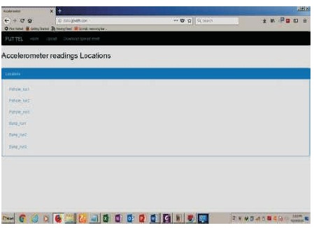
Figure 8. Road Anomalies Data Saved in the Created Database
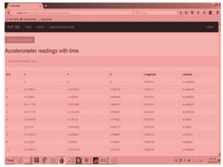
Figure 9. Content of a Sample File saved on the Database
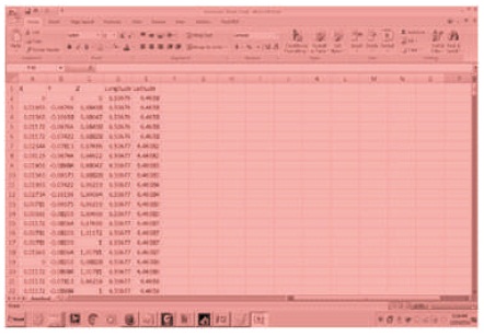
Figure 10. Downloaded Sample CSV Excel File from the Database
This paper has presented both the design and development of a road surface condition monitoring system and an online database for data storage. The database has been hosted online for public access. The sensitivity of the proposed system is predictable unlike the SBAs whose sensitivities are phone specific. In ascertaining the effectiveness of the developed database, different browsers and smart devices were used to remotely access it. This was done to demonstrate the feasibility of free access to users and interested researchers alike. Future research works will consider developing an approach for post processing the stored traces and communicating them among vehicles as in a VANET system. In addition, measures to validate the reliability of the saved data will be explored, as well as mechanism for ensuring the security of the database.