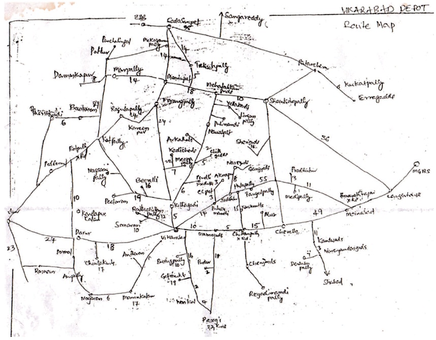
Figure 1. The Existing Hand-drawn Bus Network Layout of Vikarabad Bus Depot Jurisdiction
Topography maps prepared by survey organizations are major source of road network for any area across the world. Thematic maps showing the road network could be generated from such topography maps in the scales ranging from 1:250,000 to 1:25,000. These road maps will represent the connectivity of all the major settlements, but cannot represent few settlements (villages) in certain areas particularly, in coastal parts where the density of settlements (villages) is very high. This is due to the limitation of scale at which these maps were originally prepared. Route maps for any long routes can be derived by utilizing these maps. But planning and designing of bus route services for limited distances in the rural areas where the density of villages is high, the topo maps would not be ideal while considering the best local connectivity. The study was identified by keeping the need of reliable information of image locations put together with road connectivity in rural areas. It was observed that the concern authorities, i.e., the Road Transport Corporation (RTC) are depending up on the not-to-scale maps or Survey of India (SOI) prepared topography maps for design and planning of the Bus service routes. Such input sources could not provide the representation of interior villages/hamlets on the maps due to scale limitations.
The present study is an attempt to create large scaled reliable road network map desired by a local transport unit called a bus depot or regional management, which could be used as a reliable scientific input to the Telangana State Road Transport Corporation (TSRTC) Planning Department. These maps are used for identifying the unconnected settlements and invention of new routes, based on population analysis. This study could be a model work with redefined and accurate bus routes of both long route and local services in the study area. For example, Vikarabad bus depot of Rangareddy (old) District in Telangana State. The Geographic Information System (GIS) based route maps would enable the concerned officials to plan, design and run their public transport services (RTC Buses) as per the public requirement/ convenient and to achieve better revenues to the corporation.
As a common practice in India, topographic maps from SOI (Survey of India) have been used widely for various applications and decision making on topics or themes (e.g., population, land use, economic transactions, hydrology, agriculture, climate, soils). As a default map scale, the SOI has prepared most of the road network plans in the scale of 1:50000. These topo sheets have certain limitations. The topo sheets basically cover the waterbodies, drainage pattern, and forest areas. The habitations to their geographical reference are not positioned and also their road connectivity is not covered. In broad sense, the tertiary road system is not available to the exactness when compared to the ground position. Adjacent to this, the land use patterns are also not available.
In recent times, since 2005, the satellite imagery/Google Earth maps have become easily available. With the advent of GIS has led to the development of GPS/GIS applications (Husdal, 2000; Kanuganti, Dutta, Sarkar, & Singh, 2017). This technological innovation is allowing us to capture, store, process, and display huge database of map information, of any study area. Much of this information will be “spatially referenced” i.e. termed as geo-referenced. Such data can be easily transferred, manipulated, and analyzed in digital form. Therefore, the geometric and geographic information obtained by the use of GPS/GIS database linked thematic maps can be produced and properly represented as a road network.
This study has been conducted by the Transportation Section, Civil Engineering Department of Osmania University, Hyderabad in association with TSRTC-Vikarabad Division.
It was observed that the concerned authorities (TSRTC) depend on hand-drawn layout of Vikarabad Bus Route map (Not to Scale) for planning of Bus route services, which is not adequate (Figure 1).
Figure 1. The Existing Hand-drawn Bus Network Layout of Vikarabad Bus Depot Jurisdiction
It was observed that the TSRTC is depending upon the notto- scale maps or Survey of India (SOI) prepared old topography maps, which were drawn to scale 1:50000 for design and planning purposes of the Bus service routes. Such input sources could not provide the representation of interior/remote and unidentified villages/ hamlets on these old hand-drawn maps. This research considered and identified that there is an urgent need to update the Bus route maps with reliable information of image locations of habitations that are existing along with rural road network including the neighboring remote rural habitations.
The present project is also focused on to determine accessibility index of the unconnected habitations in the proposed GIS enabled maps for all Bus Servicer outes. Based on the above needs, the present study has been taken up with the following specific objectives.
The broad objectives of this study are listed below:
Using GIS platform for representing spatial data based on theomatic maps is a most widely acceptable practice in different countries, around the globe. A few of the important GIS based practices and also on the rural connectivity studies conducted in India are briefed below:
As a PMGSY National GIS practice of representation of rural road network, each habitation and the road links having with a unique identity number within its Block are located in GIS map superimposed over WGS84 datum and lat-long coordinates. The identified disconnected roads within such Blocks will be linked adjacent to the same identity numbers (PMGSY, 2017). There was a study conducted on PMGSY roads and found that the habitations with whose road connectivity improved than those habitations which did not have good road connectivity (TCS, 2009).
Modinpuroju, Prasad, and Chandra (2016) have developed a methodology for prioritization of the roads identified in a rural road network in Warangal District, Telangana, based on the village facility indices. They identified the maximum coverage distance of the rural road facility to design the village facility index using GIS software. Pavement maintenance priority list of the road links was prepared by calculating the link weight using gravity formula.
Shi, Blainey, and Hounsell (2017) developed a methodology for improving and proposed alternative bus route design and frequency setting for Southampton area, UK. They demonstrated making use of an optimization technique of tabu search algorithm. This methodology and the general principle can be used for improving bus transit network planning.
Jalegar and Begum (2017) developed a GIS based rural road database of Nyalkal Mandal in Sangareddy district of Telanagana State. Network analysis was conducted to select shortest and alternative paths from 39 villages to growth centre of the Mandal. Further structural analysis based on connectivity indices and maintenance strategy revealed the percent populated benefited by the link roads.
The above recent review of the literature confirms that the GIS is one of the most commonly used platforms for representing rural road network and also used for determination of new road links as well as connectivity indices with the unconnected habitations.
TSRTC is a state-owned company that runs transport services within the Indian State of Telangana. It was formed in 2014 by splitting the Andhra Pradesh State Road Transport Corporation. Many other Indian metro towns in Tamil Nadu, Karnataka, Maharashtra, Goa, Odisha, and Chhattisgarh are also linked with the services of TSRTC. It serves about 89.4 lakh passengers every day, having three zones and services operating through 95 depots (Venkatanarasimhan & Cherukuri, 2018).
Road Transport Corporation in Telangana State was first established as NSRRTD (Nizam State Rail & Road Transport Department), a wing of Nizam State Railway in the erstwhile Hyderabad State, in 1932, with 27 buses and 166 employees. Andhra Pradesh State Road Transport Corporation (APSRTC) was established on 11th January 1958 in pursuance of the Road Transport Corporations Act 1950. Consequent upon bifurcation of Andhra Pradesh state into Telangana and residual Andhra Pradesh, TSRTC operated as a separate entity from 03.06.2015. The Government of Telangana has subsequently established Telangana State Road Transport Corporation (TSRTC) (4), on 27.04.2016, under the Road Transport Corporation Act, 1950.
The Bus services are operated connecting major cities and towns in Telangana (Hyderabad, Sangareddy, Mahabubnagar, Nalgonda, Miryalaguda, Warangal, Karimnagar, Nizamabad, Bodhan, Adilabad, Nirmal, Khammam, Bhadrachalam, etc.)
TSRTC has three zones, namely Hyderabad, Greater Hyderabad, and Karimnagar. It has 13 regions, 95 depots, and 357 bus stations. TSRTC buses undertake operations on 3,687 routes, having an approximate fleet of 10,460 under its wing.
The study area considered for this project is Vikarabad, which is a town located around 70 km from the Hyderabad City, in the Ranga Reddy District of Telangana State. The town is a municipal corporation and is proposed as the headquarters of new district of Vikarabad District by the State Government. Vikarabad is also a Mandal headquarters in the Ranga Reddy Revenue District.
Vikarabad is located in the western portion of the Ranga Reddy District between 17°19' 27” N to 17°21' 25” Noth and 77° 52' 53” E to 77° 54' 51” East (Figure 2). The town has an average elevation of 638 m (2093 ft) MSL.
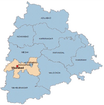
Figure 2. Map Showing Vikarabad in the Telangana State
As of 2011 India census, Vikarabad had a population of 53,185. Males constitute 26,422 of the population and females 26,763. Vikarabad has an average literacy rate of 64%, which is higher than the national average of 59.5%: male literacy is 72%, and female literacy is 57%. In Vikarabad, 13% of the population is under 6 years of age. Ranga Reddy District Police superintendent office is located at Vikarabad. Presently, Vikarabad is renowned as Rural Education centre. Engineering, Medical, Dental, Polytechnic, ITI Colleges of Education are also situated and serving the rural people for low cost. Historical Sri Anantha Padmanabha College helped its pupil to emerge as Industrialists, top administrative officers, politicians, software engineers, and professionals in many other fields.
The Vikarabad town is connected by a well maintained road network of local roads with all Mandal headquarters connecting almost every revenue village in the neighborhood and runs all kinds of services to Hyderabad, by every half an hour interval. The other major destinations that are connected with Vikarabad are Mahabub Nagarand, and Sanga Reddy Districts.
The present research work involves the following major stages in achieving the desired outputs that could be practically useful to the cliental organization. The following are the factors and steps considered for development of bus service routes of Vikarabad District.
Reference data, i.e., high resolution Satellite imagery for the research work is downloaded from Google Earth Pro software. The data is downloaded into 8 part images and geo- referenced using Global Mapper 9.0 Software. All the geo-referenced part images were used for creating road and village location features in ARC Map Software (Figure 3).
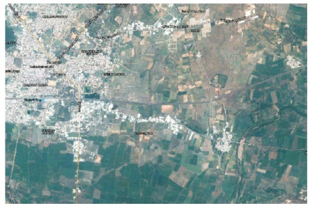
Figure 3. Google Image of the Study Area
ArcMap 10 version of GIS software has been used to create all the vector data (i.e. spatial database) of the project. Google Earth imagery in Geographic projection system has been used as the reference input data to generate the proposed road network of the study area. Working environment of ARCMAP has been used in creating the vector maps of the project area (Figure 4).
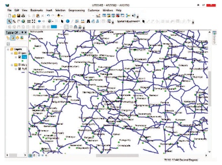
Figure 4. Vikarabad Road Network Working Environment on GIS software- ArcMap 10
The below map is also incorporated and updated with unconnected settlements / habitations. The proposed new routes were also incorporated in this map by connecting unconnected settlements with the existing raw data obtained from RTC-Regional Manager Ranga Reddy District and population data from various Tahasildhars of respective Mandals.
In the present study, a methodology for rural road planning has been evolved which is primarily based on the accessibility concept.
In the present study, a methodology for rural road planning has been adopted which is primarily based on the accessibility concept as recommended in IRC:SP:20. As a fundamental concept, any rural road planning should consider integrated area development by spatial distribution of origin-destination trip functions in a region. The rural road network should be planned in such a way that they serve rural functional requirements of each unconnected habitation in an efficient manner (WB, 2002). The proposed link connectivity should provide accessibility to various functions available in the study area, to all the existing roads with the unconnected habitations.
There are several methods available for development of optimal network for rural road connectivity. The concept of rural road network planning as per IRC:SP:20 (2002) is briefed below.
Conventionally habitations and the population size have been considered as priority for provision of all-weather road connection. For example, Bombay, Lucknow (20-Year) Road Development Plans and also in Pradhan Mantri Gram Sadak Yojana (PMGSY) scheme considered population criteria for determination of rural road length requirement. The integrated rural road development approach aims to provide access to habitations based on various service facilities and utility value. The utility value for the habitation considers a set of factors related to demographic, socioeconomic, infrastructure, and development data. This composite measurement of integrated development is termed as Utility Index (UI) of the habitation. The selected set of these variables may differ with the study area. Each variable can be accounted based on the weightages as recommended by IRC:SP:20 (Table 1).
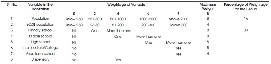
Table 1. A Partial Table Showing Relative Weights for Variables (Source: IRC:SP:20, 2002)
Utility values are calculated for all habitations with population size 100 and above and used for the prioritisation of habitations.
The available options of connectivity for habitations shall be guided by the following assumptions which are in order to develop rural road network so that it adequately meets the accessibility requirement of the unconnected habitations:
The above assumptions are the basis for the development of rural road network in a Block or a District in a structured manner as described in Figure 5. The best link option shall be selected as the one with highest benefit of connectivity and it is directly proportional to the population sizes of all the habitations it serves or indirectly in proportion to the Utility Index values of the habitations (Equation (1)). If a road link serves more than one unconnected habitation, a weighted average of UI may be adopted based on the length portion proposed link.
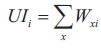
where,
UIi = Utility index for habitation i, and Wxi = weight for xth facility for habitation i.
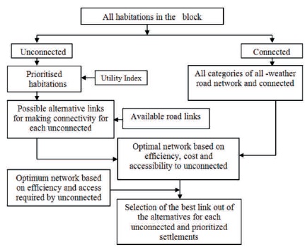
Figure 5. Approach Adopted for Rural Road Network Connectivity of Habitations
Trip rates are calculated using the regression equation (IRC:SP:20):
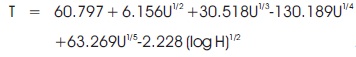
where,
T - Trip rate of the ward
U - Utility value or Ward index
H - Number of occupied households in the village.
It is now possible to develop the rural road network using various criteria in selecting the best link option, which provide connectivity to the unconnected settlements. The accessibility in terms of UI developed in previous section can be used for developing the network. This network is the most efficient in serving the missing functional requirement of unconnected settlements. The stepwise procedure adopted to develop the network is given below:
Based on the trip rates, the habitations which are connecting maximum trip rates are chosen to develop a link between the connected and unconnected settlements. Finally four new routes are identified with the existing bus services (Figure 6) and they are listed in Table 2.
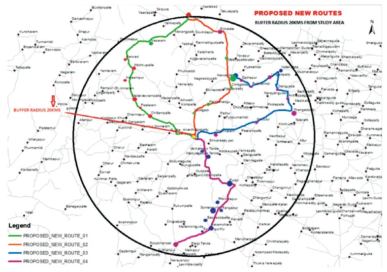
Figure 6. The Proposed Four New Routes in the Study Area
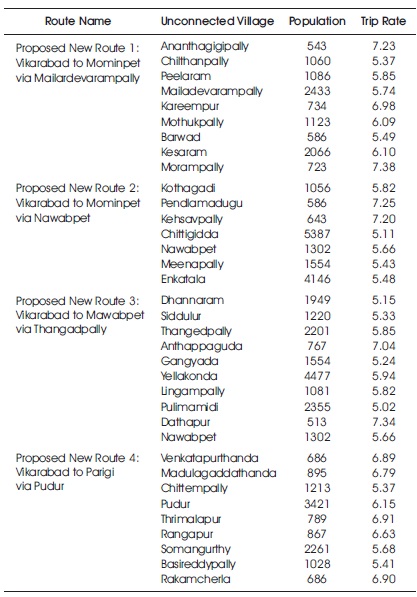
Table 2. The New Routes Identified with the Existing Bus Services
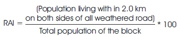
This study utilizes Rural Access Index (RAI), one of the several transport accessibility Indicators suggested by the World Bank (Limi et al., 2016; Starkey, Ellis, Hine, & Ternell, 2002). RAI has been adopted for the results measurement system of the 14th International Development Association (IDA). Under the PMGSY guidelines, a habitation is considered to have connectivity, if there is an existing all weather road within half a kilometer of the habitation. In case of hilly and desert areas, this distance taken as one and a half kilometer. The value of RAI by IDA criterion is expressed in equation (3).
Rural accessibility Indicator as per PMGSY criterion RAI is expressed in equation (4).
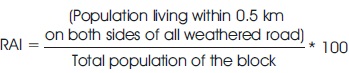
In this analysis, the second method is used to measure RAI as per IDA and PMGSY definition using GIS platform. The populations within the bands such as 2 km and 0.5 km are found using the buffer tool in ArcGIS 10.2. The newly proposed four rural roads RAI values as per IDA and PMGSY Criteria are presented in Table 3.
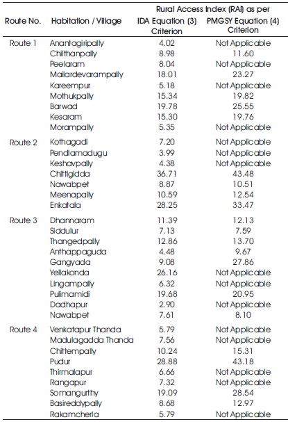
Table 3.The Proposed Rural Road Access Index (RAI) Values as per IDA and PMGSY Criteria
The summary of the present study and the conclusions drawn based on the data analysis are presented below.
The Vikarabad road network mapping was performed by applying remote sensing and GIS based methodology including existing map data. This GIS map can be used for planning and management of bus services in the Vikarabad Bus Depot by Regional Manager of TSRTC. Unconnected habitations were identified within 20 km radius, encircling Vikarabad town and new four new bus routes developed. The population data of unconnected habitations which required were collected from Thahsildhars of respective Mandals and the related accessibility indices are determined.
The following conclusions can be drawn based on the present work.