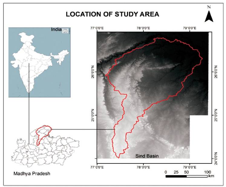
Figure 1. Location of the Sind River basin in Madhya Pradesh
Watershed is one of the important essential contents for many multidisciplinary researches, such as water harvesting, watershed management, morphometric analyses, land use and land cover change analyses, soil types, geology, geomorphological analyses, river flows studies, etc. The delineation of watershed can be done either manually from topographic sheets or derived from Digital Elevation Model (DEM) data using computational methods. In the last few decades, Geographic Information Systems (GIS) are proving valuable tools in many hydrological as well as natural resource environments. In the present study, automated spatial delineation of watersheds have been done using ASTER DEM data with the help of ARC SWAT (Soil and Water Assessment Tool) model. This methodology is executed on a geospatial software such as ARC GIS in which ARC SWAT performs as a tool of ARC GIS. The Sind River basin has been taken as the study area which covers about 27,905 km2 and seventeen watersheds have been delineated using ARC SWAT. Some of the major watersheds are that of Pahuj, Parbati, Kunwari, Vaishali, and Upper Sind catchment. The drainage network has been extracted and the patterns of the drainage have been studied. It was concluded that this methodology is also suitable for low spatial resolution of DEM (30 m). Further for the delineation of several watersheds from a large area technique, not only saves time, but also provides splendid results. The study demonstrates the importance and reliability of ARC SWAT tool for automated delineation of watersheds and drainage network from ASTER data.
A watershed is generally defined as an area of land where all water drains to one location such, as a stream, lake, or wetland. A watershed is an area which shares a common drainage point (pour point), where water follows to natural slope conditions (USGS Water Science School). Delineation of watershed and drainage network is very important as it is the basic unit for many important studies. These studies are multidisciplinary in nature. Some of the important studies in watershed are water harvesting studies, watershed management studies, morphometric studies, land use and land cover change analyses and geomorphological analyses, etc. However, the method of watershed and drainage network delineation are basically two types of manual delineation method using topographic map sheets and automated delineation method using Digital Elevation Model (DEM). In earlier days delineation of the watersheds were done by tracing the water divides by following the contour lines. Later on people started digitizing the watershed boundary to delineate the watersheds and drainage network delineation can be directly digitized on a digital computer screen over a topographic maps sheets. Now-a-days normally it is done through DEM using GIS software. Many researchers have tried successful automatic watershed delineation studies. (Band, 1986; Jenson and Domingue, 1988; Martínez- Casasnovas and Stuiver, 1998; Arnold et al., 1998; Venkatachalam, 2001; Tripathi et al., 2003; Setegn et al., 2008; Kumar and Dhiman, 2014).
In ARC GIS software, using Spatial Analyst tool, one can delineate watershed and the drainage network. A more advance tool ARC SWAT is used for delineating watershed in the present study.
The major objectives of the present study are,
The Sind River runs through Madhya Pradesh and Uttar Pradesh and is a major tributary of the river Yamuna. It originates on the Malwa Plateau in Vidisha district, and flows north-northeast through the districts of Guna, Ashoknagar, Shivpuri, Datia, Gwalior and Bhind in Madhya Pradesh and just after the confluence of the Chambal river, it joins the Yamuna River in Etawah district, Uttar Pradesh. The geographical co-ordinates of the mouth of Sind river is 26°26′17″N latitude 79°12′43″E longitude. It has a total length of 470 kilometers out of which 461 kilometers are in Madhya Pradesh and 9 kilometers are in Uttar Pradesh. Pahuj, Kunwari, Vaishali, and Parbati are its major tributaries. The location of the study area has been shown in Figure 1.
Figure 1. Location of the Sind River basin in Madhya Pradesh
A Digital Elevation Model is basically a 3D representation of a terrain's surface created from terrain elevation data, which is extracted from Advanced Space Bourne Thermal Emission and Radiometer (ASTER) DEM. ASTER has spatial resolution 30 meter and has been used in the present study.
ARC GIS software has been used extensively in the present study particularly ARC GIS spatial analyst extension, the ARC Hydro tools, and the ARC SWAT. SWAT is a public domain hydrologic model. SWAT stands for Soil and Water Assessment Tool. It is normally used for large watersheds to the soil, land use, topography, channel morphology, crops, etc., of a particular watershed. SWAT has been very successfully applied to many major river systems by various Scientists.
The methodology adopted for the study has been shown through a flow chart of watershed and drainage delineation in ARC SWAT and Spatial Analyst extension of ARC GIS software in Figure 2. There are seven basic steps which was followed in the ARC SWAT along with four steps in Spatial Analyst extension.
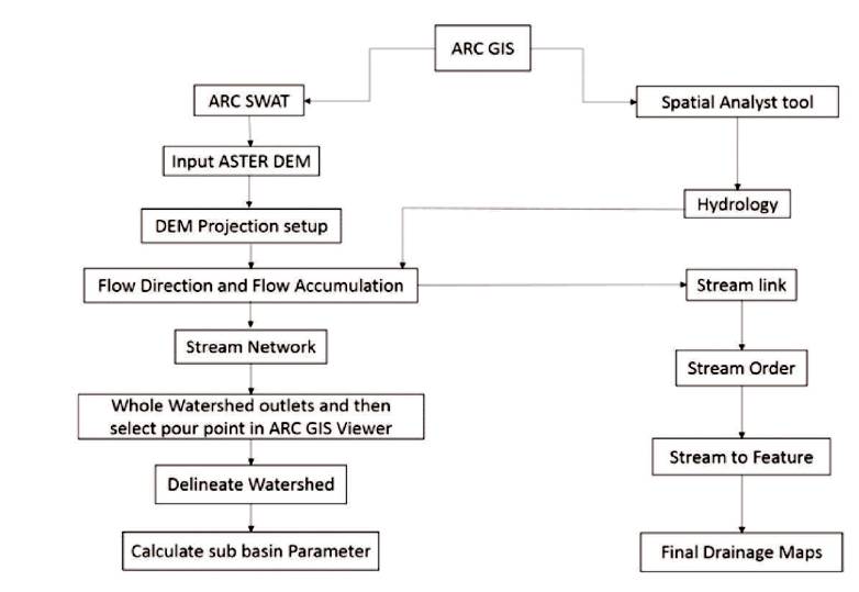
Figure 2. Flowchart showing the Methodology
Initially the downloaded ASTER DEM data was used as input to the ARC SWAT in ARC GIS, which is followed by the DEM projection set up. The spatial reference was WGS 1984 with UTM zone 44 N. The cell size considered was 30 metre. Subsequently flow direction and flow accumulation was determined followed by stream network generation. Then the pour point is assigned using ARC GIS viewer to the whole watershed outlet, which finally delineates the watersheds. Subsequently the basin parameters were calculated. The flow direction and flow accumulation map from the ARC SWAT was used in the Spatial Analyst tool by using the hydrology tool set and subsequently the stream order, stream to feature, and final drainage maps were prepared.
The difference between the flow accumulation values of the cell which flow to form its own flow accumulation value is determined for each cell. Along the drainage network, the cell is marked as a pour point or outlet point with a condition that the difference is greater than given threshold. This procedure identifies all the possible pour point on the drainage network (Venkatachalam et al., 2001). For delineation of watershed, a pour point of a stream is selected and the cells contributing the flow to that stream are marked as a subwatershed (Jenson and Domingue, 1988). As a result we get 17 different watershed of Sind river basin which is shown in Figure 3.
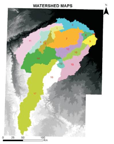
Figure 3. Watersheds Boundaries of Sind River Basin
The major watersheds are determined as Kunwari, Vaishali, Parbati, Pahuj, Upper Sind, Outlet of Sind, which are shown in Figure 4.
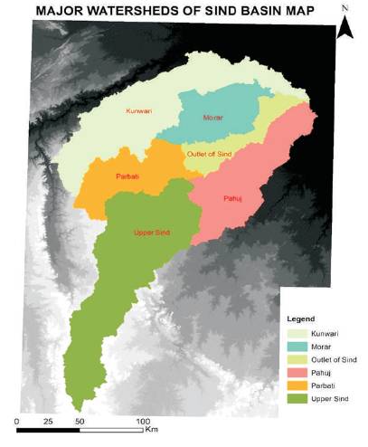
Figure 4. Major Watersheds of Sind River
The cells in the matrix that have flow accumulation value greater than the user defined threshold value defines the drainage network. Hence, the matrix is thoroughly scanned and all cells with accumulation value greater than the threshold are considered to form the drainage network. The drainage pattern of sind river basin is shown in Figure 5.
The identified drainage pattern are shown in extended view in Figure 6.
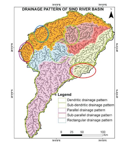
Figure 5. Drainage Pattern of Sind River Basin

Figure 6. Extended view of Identified Drainage Patterns
This present study concludes that seventeen watersheds have been delineated using ARC SWAT out of the area coverage of about 27,905 km2 . The drainage network has been extracted and the patterns of the drainage have been identified. This methodology is proven for low spatial resolution of DEM (30 m). For the delineation of several watersheds and drainage networks from a large area, the technique not only saves time, but also provides accurate results. Hence the study demonstrates the importance and reliability of ARC SWAT tool for automated delineation of watersheds and drainage network from ASTER data. The result shows that the automated delineation method was more consistent than the manual delineation method in terms of time consuming and accuracy.