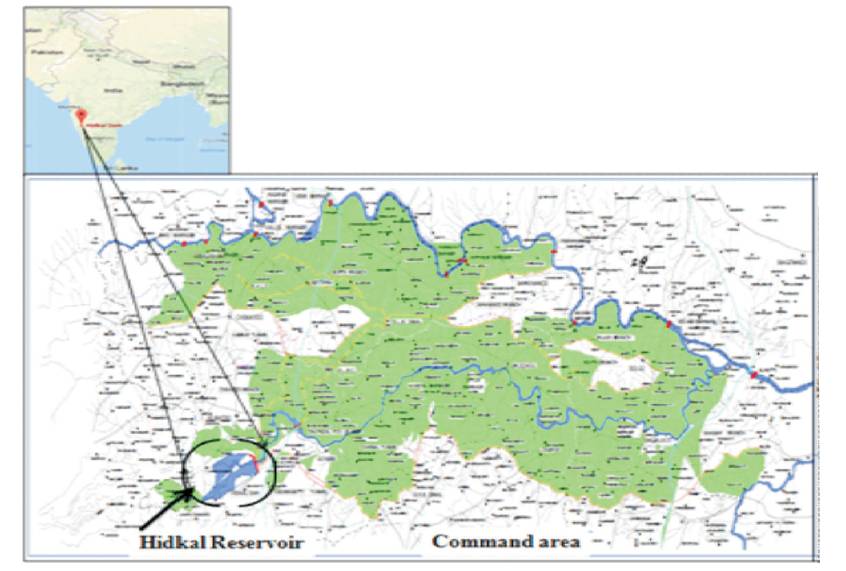
Figure 1. Location Map of Ghataprabha Command Area (Source: Office of the Chief Eng. KNNL, Irrigation-North, Belagavi)
A study is carried out to determine the crop water requirement of some selected crops for the Ghataprabha command area situated in the state of Karnataka, India. Crop water requirement for each of the crops is determined by using 30- year climatic data in CROPWAT. Reference crop EvapoTranspiration (ET ) is determined using the FAO Penman Monteith o method. The crop water requirement and net irrigation requirement in the command area are determined for different hydrological years, viz., average, dry (P80), wet (P20), and normal rainfall (P50) scenario. The results of the modeling framework indicate that irrigation demand is highest during dry scenario and lowest for wet scenario whereas the water demand during normal scenario is well approached by that in average scenario. Kharif crops have lower irrigation water demand compared to other cropping criteria. Whereas the two seasonal crops require the highest water for cultivation compared to Kharif and Rabi crops. The proposed modeling framework recommends farmers to select most suitable scenario for better management of agricultural water resource.
More than one third of the world's population relies on agriculture as their occupation, with the largest portion being in Asia. Agriculture plays a key role in economic growth of developing countries contributing nearly 30 percent of GDP (FAO, 2013). In India, Agricultural sector has been given due weightage in every five year plan realizing the importance of its vital role in the development of the nation (Rao et al., 2001).
Over the last five decades World agricultural production has improved from 2 to 4 percent per annum, but there is only 1 percent per year increase in the cultivable land which includes permanent cropland and arable land. Due to climate change, the rainfall has become uneven, scanty and unreliable because of which irrigated area has doubled in the recent time which contributes more than 40% increase in food production (FAO, 2002, 1992, 2013).
Agriculture requires two essential resources, Soil and water resource. It is a well known fact that second important resource for agriculture is the water resource, particularly the fresh water which is getting scarce day by day because of various reasons, such as industrialization, urbanization, evolving life style and luxurious living standard of the people, etc., which are also the main reasons for increasing water demand. It is further predicted that if the global temperature rises by 2 oC, one fifth of the global population will suffer from huge deficiency of water. One of the best suitable means of addressing this problem of water shortage across the world is to increasing the productivity of available water resources (Cornejo et al., 2006). Nearly 80-90% of available water resource is used only for irrigating agricultural area in most of the Asian countries including India. The target should be set to gain maximum returns with minimal/ optimal use of water in the agriculture, sparing the water for other essential usage (Safari and Falsafioun, 2017). In order to bring about judicious, optimal allocation and management of water resource it requires the thorough knowledge and understanding of the actual evapotranspiration and irrigation water requirement (Banerjee et al., 2016). Hamid et al., (2016) studied the crops under various scenarios and revealed that farmers have common tendency to overirrigate the crops which is not acceptable. Further a study conducted by Shreedhar et al., (2015, 2016) in Kunigal command area proved that crop evapotranspiration (ETo ) of crops with lengthier growing period was higher compared to the ones having lower growing period besides computed ETo was higher in dry period than the rainy season.
The local farmers because of their conservative attitude practice traditional methods of farming makes wasteful mode of valuable irrigation water which leads to loss of water as well as lowering in yield. They do not know when to irrigate, how much to irrigate their crops, since different crops have different quantity of water requirement. Hence the role of estimation of Crop Water Requirement (CWR) becomes essential. The work performed by Shreedhar et al., at Markandeya command area using CROPWAT for computing crop water requirement suggests farmers to have sufficient knowledge of type of crops to be grown under different conditions in order to bring about optimal use of water (Ghamarnia et al., 2012).
A well planned and operated complex irrigation system require accurate estimation of Irrigation Water Requirement (IWR) which leads to efficient use of water resource saving the water retaining of which can be made use in dry seasons (Aftab Hasar et al., 2011; Azhar and Perera, 2011).
The proposed study is carried out on the Ghataprabha Command Area (GCA). The Ghataprabha Project and its Command area lie in the jurisdiction of seven talukas of Belagavi district and six talukas of Bagalkot district. It comprises of Athani, Chikkodi, Gokak, Hukkeri, Raibag, Ramdurg, Savadatti, Badami, Bagalkot, Bilgi, Hungund, Jamkhandi, and Mudhol Talukas of Belagavi and Bagalkot district, respectively. A greater portion of Belagavi district comes under the Northern Dry zone and left over area falls under the Northern Transitional zone and Hilly zone. The eastern part of Belagavi and whole of Bagalkot district lies in the arid zone and therefore, presently coming under famine stricken area. Taking into consideration of all the above factors, the proposed work is carried out with an objective to calculate the reference Evapotranspiration and net irrigation requirement of crops in the study area for different hydrological years by using CROPWAT model.
Hidkal dam also known as Raja Lakhamagowda dam and presently it is the biggest dam in Belgaum district, Karnataka. It is situated at Hidkal village in Hukkeri taluka of Belagavi district in North Karnataka, India. It was started for generating hydroelectricity and for supplying drinking water and water for irrigation. The dam is constructed across the Ghataprabha River in the Krishna River basin. It is having a catchment area of 1412 Sq. km located at an Latitude of 16o-09'-0" North and 74o-38'-0" East Longitude. It is constructed as a part of the Ghataprabha Irrigation project which was completed in three phases and finished in 2009. It is a composite type of dam which caters to the irrigation needs for over 7, 84,400 acres of area.
The Ghataprabha Command Area (GCA) as shown in Figure 1 is situated at an elevation of 600 m MSL which covers dry and arid tract in the Deccan Plateau. The region has great significance from agricultural point of view since it lies in eastern belt. The command area climate is mostly temperate when compared to other places it is having neither extreme heat nor cold.
Figure 1. Location Map of Ghataprabha Command Area (Source: Office of the Chief Eng. KNNL, Irrigation-North, Belagavi)
The temperature rises to as high as 42 oC in summer and descends to minimal of 20 oC. Average annual rainfall in the command area is 553.8 mm. The command area witnesses the soil composition ranging from fine textured to moderately fine and moderately coarse textured to medium textured soil.
In the present era there is a huge drift in the development and application of computer simulation models for easier solution of complex problems pertaining to water resource management. CROPWAT is a windows-based decision support tool developed by water and land division of FAO with the assistance of the Institute of Irrigation and Development Studies of Southampton of UK and National Water Research Center of Egypt. It is extensively used by water resource personnel, agronomist, scientists, engineers, and research scholars throughout the world for solving many water related problems. It estimates reference evapotranspiration based on Penman – Monteith method. CROPWAT assist in computation of crop evapotranspiration, crop water requirement, and Net irrigation requirement, and in formation of irrigation schedule, cropping pattern, rain fed or deficit irrigation. The results of various studies indicated that the CROPWAT model is a reliable tool in understanding CWR, irrigation planning, and manage irrigation scheduling (Luo et al., 2015). It is relatively simple, user-friendly, and has an easily interpreted output (Kang 2009). The main input data required for CROPWAT are crop data, soil data, and climatic data. Table 1 clearly illustrates the input data required and possible outcomes from the CROPWAT.
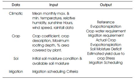
Table 1. Input Data for CROPWAT Model with Possible Output
The past 30 years rainfall data have been collected from district statistical office, Belagavi. The meteorological data, such as maximum/minimum temperature, humidity, sunshine hours, and wind speed have been obtained from IMD station located at Hidkal village.
Reference evapotranspiration estimated from the theoretical reference standard crop called Alfalfa which can be defined as an actively growing, uniform surface of grass completely shading the ground which is not short of for its profuse, uninterrupted growth. The Evapotranspiration of crop under consideration can be obtained by adjusting ETo using crop coefficient. The crop co-efficient is crop specific varying at different stage of crop growth.
The ETo values obtained from the CROPWAT for different months are as shown in Table 2. The ETo is highest for May month and lowest during December with value of 5.36 mm and 3.25 mm, respectively.
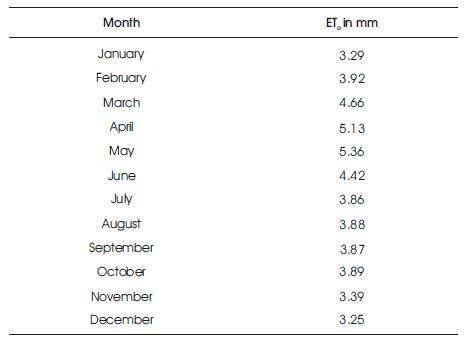
Table 2. Reference Evapotranspiration Calculation by CROPWAT for the Study Area
The effective rainfall is defined as the part of rainfall which is effectively used by the crops after contributing to the losses, such as surface runoff and deep percolation. Effective rainfall is the one, eventually used to estimate crop water requirement. The three main characteristics of rainfall are its amount, frequency, and intensity which vary from place to place, day to day, month to month, and even from year to year. Precise knowledge of these three main characteristics is essential for planning its full utilization.
The proposed study targeted towards analysis at two different scenarios of precipitation. These scenarios provides a strong firm for selecting and recognizing most suitable plan for agricultural water resource management. The objective is to get most out of (Maximize) farm yield under different hydrological years ensuring least risk to disruption to profuse crop growth.
Scenario I : Average annual rainfall of past 30 years are being used for estimation of effective rainfall.
Scenario II : Rainfall has been classified into three hydrological years, namely Dry year, normal year, and wet year rainfall corresponding to probability of exceedence 80, 50, and 20, respectively.
CROPWAT provides four methods for the estimation of effective rainfall which include: Percentage method, Empirical method, Dependable rainfall, and USDA S.C. method.
The four scenarios of rainfall, namely average, dry, wet, and normal are useful for the programming of irrigation supply and simulation of irrigation management conditions. The rainfall for different scenarios is as shown in Table 3.
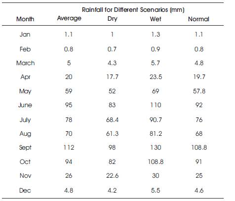
Table 3. Rainfall for Different Scenarios
The rainfall in normal years (50% probability) is, in general, well approached by the average rainfall shown in Figure 2. The plots of rainfall and effective rainfall for average, dry, wet, and normal scenarios is as shown in Figures 3, 4, 5, and 6, respectively which indicates that about 87%, 87.4%, 85%, 88.6% of rainfall have been used effectively by the crops. The annual rainfall value for average condition is about 565.7 mm and 549.6 mm for normal scenario. Whereas the annual rainfall for dry and wet scenario is 495.2 and 656.6 mm.
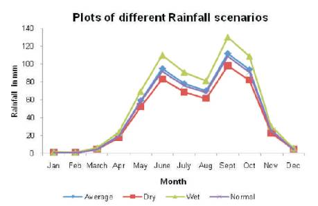
Figure 2. Plots of Different Rainfall Scenarios
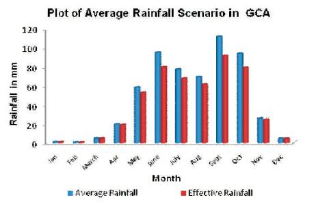
Figure 3. Effective Rainfall for Scenario I
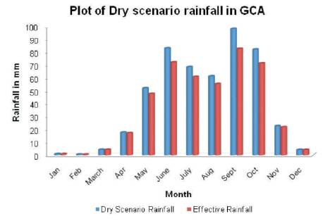
Figure 4. Effective Rainfall for Dry Scenario
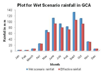
Figure 5. Effective Rainfall for Wet Scenario
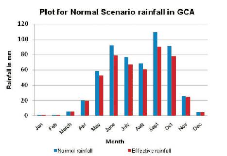
Figure 6. Effective Rainfall for Normal Scenario
The crop water need is defined as the depth (or amount) of water needed to meet the water loss through evapotranspiration. Naturally different crops may have different water requirements at different places of the same country, depending upon the climate, type of soil, method of cultivation, effective rain, etc. The total water required for crop growth is not uniformly distributed over its entire life span. The crop evapotranspiration is estimated using the following relation.

where,
ETc -crop Evapotranspiration in (mm/day)
Kc -crop coefficient,
ETo -Reference crop evapotranspiration in (mm/day)
Net irrigation requirement is the quantity of water required for the crop growth. It can be termed as the amount of water needed to bring the soil to field capacity. It depends on the cropping pattern and the climate. Information on irrigation efficiency is necessary to convert NIR to Gross Irrigation Requirement (GIR). The various losses, such as seepage, percolation, runoff, evaporation takes place during conveyance and application irrigation water.
The operations, such as land preparation, leaching, and transplantation require some amount of water. Therefore water requirement of crop comprises of Evapotranspiration, losses during application and water required for special purpose.
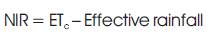
The results obtained from effective rainfall analysis and CROPWAT simulation indicate that the net irrigation requirement of crops is obviously highest during dry condition compared to other hydrological scenarios and lowest during wet scenario as shown in Table 4 and Figure 7. The NIR for different crops in the command area for Average scenario is well approached by that in normal scenario (Figure 7). The Kharif crops like Groundnut, Hybrid Maize, Hybrid and local Jowar, and Millet require less amount of water compared to other two seasons as most of the water need is satisfied from rainfall.
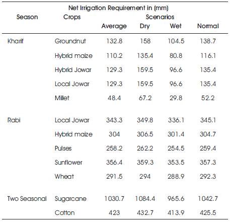
Table 4. NIR for Crops in the Study Area From CROPWAT
Figure 7. Plots of Net Irrigation Requirement of Crops in Study Area Under Different Scenarios
Rabi season crops which include Local Jowar, Hybrid Maize, Pulses, Sunflower, and Wheat require moderately more water compared to Kharif crops, but lesser than two Seasonal crops. Here there is not much variation in the irrigation requirements under different scenario. The two seasonal crops like Sugarcane and Cotton require highest amount of water compared to all other type of crops as shown in Figure 7. This kind of analysis help farmers to choose the type of crops for cultivation based on the availability of water or rainfall scenario.
The following conclusions can be made by the present study: