Figure 1. Kodagu District Map
In emerging technology paradigm, “Geographical Information System (GIS)” has emerged as a powerful tool which has the potential to organize complex spatial environment with tabular relationships. For the present work, study area considered is Kodagu District of Karnataka State where 1412 Sacred Groves (SG) are identified. SGs are the places where biodiversity will be preserved based on religious beliefs. Present work describes how GIS tools can be utilized effectively to manage and disseminate the spatial data and its role in conservation of SG which is the need of the day. During field visit, totally 851 species have been studied, out of which 91 are Tree species, 59 are Medicinal plant species, 16 are animals and 26 are bird species. It has been found among these that 2 are Critically Endangered, 1 Endangered, 7 vulnerable Tree species, and 2 Endangered,4 vulnerable animal species and 26 least concerned bird species can be seen in SGs. Open Geo Suite application proved to be effective not only in visualization, but also in dissemination of data as well as answering the location/attribute based queries. From the study, it can be concluded that, GIS tools and Open Geo Suite applications are effective in supporting conservation and sustainable management of this age old tradition.
In emerging technology paradigm, “Geographical Information System (GIS)” has emerged as a powerful tool which has the potential to organize complex spatial environment with tabular relationships. The emphasis is on developing digital spatial database; its management has been recognized as a very essential parameter needed for all types of conservation. A Geographic Information System provides a framework to document and store, manipulate, retrieve and manage, various forms of spatial data and non spatial data. The GIS data is used to perform spatial analyses, statistical queries, and predictive modeling of large, complex datasets. The results of this analysis can then be shown using visually intuitive maps. Apart from this, GIS also has the advantage of applications that provide a cost-effective way to create custom database interfaces, and has analysis tools, and data dissemination tools for a large variety of users. GIS technology comes at the top of the technologies that favor biodiversity conservation applications, as it would assist in the sustainable management of natural resources, which is a major component of any biodiversity strategy (B.B. Salem ,2003. [2] ).
These are patches of natural vegetation preserved by ancient societies on religious and cultural traditions. These have been described variously as natural museums of giant trees, treasure houses of threatened species, dispensaries of medicinal plants, regulators of water sheds, recreation centers for urban life, veritable gardens for botanists, gene banks of economic species, paradise for nature-lovers and laboratory for environmentalists Ramanujam and Kadamban 2001[9], Parthasarathy Venkateswaran, Reddy, and Mani, 2005[10]. & Sukumaran and Jeeva 2008) [12]. These SGS are very ancient and widespread phenomenon in the old world cultures. They are mentioned in the Greek and Sanskrit classics and reported to exist even today in a number of countries besides India, e.g., Ghana, Nigeria, Syria and Turkey (Gadgil, Madhav, and V. D. Vartak.1975). SGs are considered as important because they are elements linking nature and culture, areas of high biological diversity, sanctuaries of threatened species, sites that protect fresh water source. (http://www.cgforest. com/media/Sacred_Groove1901.pdf.) [17]. These SGs were well protected in earlier days but at present, SGs and their habitat is being disturbed because of the various anthropological activities and diminishing tradition values. In order to protect these SGs from further diminishing, wisely and timely measures have to be taken. But like conservation of biodiversity, conservation of SG is also a tedious job. A data on scared groves is vast, it is also distributed, scattered and available in variety of forms, formats and conditions. Hardly any data is digitized or available in electronic formats. In fact, much of the data is not even documented and is available only as folklores, tales and is being passed from generation to generation; hence poses the challenge of maintaining its integrity and authenticity. Further, not same amount and nature of data is available on all scared groves, as some of them are studied in great details and many of them are not even surveyed yet. Hence, there is great heterogeneity in nature and amount of information available on various sacred groves (Gaikwad, S. N. Paralikar, Vishwas Chavan and S. Krishnan. 2004) [4]. This calls for a technology which is capable of handling diversified data , which supports taking decisions, and it was found that, participatory GIS mapping processes contributed – positively, though not comprehensively – to good governance, by improving dialogue, redistributing resource access and control rights – though not always equitably – legitimizing and using local knowledge, exposing local stakeholders to geospatial analysis, and creating some actor empowerment through training. PGIS (Participatory GIS) promoted empowerment by supporting community members' participation in decision-making and actions, and by enabling land use planning decisions beyond community forestry itself.(Michael K Mc.call ,Peter AMinang 2005) [5].
It is a database designed to store, query, and manipulate geographic information and spatial data. It is also known as a spatial database. It defines the generic model for geographic information. This generic model can be used to define and work with wide variety of different user- or application-specific models. By defining and implementing a wide variety of behavior on a generic geographic model, geodatabase model supports an object-oriented vector data model. In this model, entities are represented as objects with properties, behavior, and relationships. Support for a variety of different geographic object types is built into the system. These object types include simple objects, geographic features (objects with location), network features (objects with geometric integration with other features), annotation features, and other more specialized feature types. The model allows to define relationships between objects, together with rules for maintaining the referential integrity between objects. Geodatabase has been widely used for its advantages. By using Geodatabase, Florida’s wetlands were identified and mapped (Mathiyalagan, S. Grunwald, S. Grunwald, S.A. Bloom 2005) [13]., Flood potential area have been identified for Catalonia (M. Barnolas and M. C. Llasat - 2007,) [7]. Geodatabase is used in the management of fisheries in Southern Brazil. (Débora M. De Freitas, Paulo Roberto A., Tagliani, 2008) [8] and information on placer gold deposits can be updated, queried, visualized, and analyzed for offshore marine placer gold at Nome, Alaska (Wei Zhou, Gang Chen, Hui Li, Huayang Luo 2007) [14] .
It is a complete geospatial platform for managing data and building maps and applications across web browsers, desktops, and mobile devices. Built on leading open source geospatial software, Open Geo Suite has a robust and flexible architecture that enables organizations to reliably manage and publish geospatial data. Web mapping helps in launching spatial data on the web which allows for better visualization as well as sharing of data over the internet. These maps can be overlaid on google earth satellite imagery as the base map. These maps were published in Geo explorer whereby a link to the web was produced and the maps were launched on Mozilla web browser. There is a need to develop more Web-based tools to share environmental datasets, information and sharing of historic, current, and future geospatial datasets which will reduce costs, avoid funding of redundant research projects, and enable continuous documentation. Decision-makers and administrators often have a very limited expertise in GIS and complex spatial analyses. WebGIS has the potential to share data, provide easy access for users with limited GIS knowledge, and assemble data and information customized for specific topics, such as wetlands of Florida, where an Interactive Web GIS and Geodatabase for Florida's wetlands was developed in order to provide map and data services that supports in assisting the decision-making process to restore and preserve wetlands of Florida. (Mathiyalagan, S. Grunwald, S. Grunwald, S.A. Bloom 2005) [13].
Web-based Geographic Information Systems (webGIS), a hybrid of GIS and Internet technologies, are a promising option for entering and storing heterogeneous datasets, indexed by location, and making them widely available in a visual, dynamic, and interactive format. Although webGIS has the potential to increase public participation in environmental management, there are technical, institutional, and social challenges to its implementation and usage that need to be addressed; including differential Internet access, training, and privacy. An Open source Web -GIS application aims to educate the local communities on the importance and threat faced by SGs so as to rejuvenate unity among them for their participation in the conservation of these traditional institutions. (B.Shushma Shashi., G.S. Dwarakish. K.B Kiran. 2014,) [1].This low cost technology is easy to handle, manage and maintain upto date database. The database was effectively created and is being used for the forest resource management in Ghana (Masakuni Nakayama, Bhuwneshwar Prasad Sah, Raghunath Jha, SenthilSelvaraj. 2014,) [6].
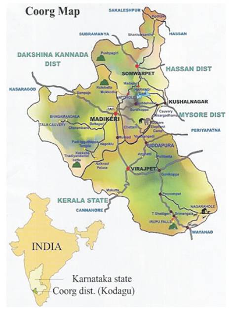
The study area considered for the present work is Kodagu district, as represented by Figure 1, which is also called as Coorg District, situated in the southern part of the Karnataka State. The district is famous as “Kashmir of Karnataka” because of the pleasant weather conditions. The district lies between North latitude 11°56' to 12°56' and east longitude 75°22' to 76°11. Kodagu district covers an area of 4102 Sqkms and the main river of the district is Cauvery, which originates at Talakaveri and is located on the eastern side of the Western Ghats, with its tributaries, draining the greater part of Kodagu. The district is famous for the tropical evergreen forest and is the home for DevaraKadu/Devarabana (SG). Sacred groves exist all over India and in the rest of the world but, the SGs of the Kodagu makes the district unique as this little district has the highest density of SGs with about officially listed 1214 SG. The district has three wildlife sanctuaries: Brahmagiri Wildlife Sanctuary, Talakaveri Wildlife Sanctuary, and Pushpagiri Wildlife Sanctuary, and one National park, nagarahole or Rajiv Gandhi National Park.
Figure 1. Kodagu District Map
For the present work Survey of India, Toposheets of 1:50,000 Scale, GPS data, Ground truth data, information from localities and from various departments have been collected and captured, stored, managed, analysed and visualised by using softwares such as Erdas imagine 9.1,ArcGIS 10.2, Garmin Mapsource, Open Geosuite 3.0.2
For Base map preparation, SOI Toposheets of 1:50,000 scale has been used and study area has been traced, scanned and then Georeferenced to WGS 1984 projection. Then it is reprojected into UTM 43N Projection. Each Subset is processed to obtain single mosaic of the district. Later the details of district boundary, Taluk Boundary, Road Network, River Network, Drainage Network were digitized and stored in different layers in the form of .shp file. Methodology for the preparation of Base map is represented in Figure 2 and Figure 3 shows the digitized Base map.
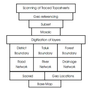
Figure 2. Base Map Preparation

Figure 3. Digitized boundaries of District and Taluk, major roads, reserved Forest boundary, Drainage network and Base Map of Kodagu District.
The Methodology adopted to build a SG Geodatabase is as follows. Spatial data as well as all the related Biodiversity data and Sociological data of SGs have been collected from the field. These data has been converted into shapefiles of Geographic WGS 1984 projection. Then schema for SG Geodatabase has been prepared and according to the schema, file based Geodatabase has been created. This Geodatabase contains different Feature data sets to which after reprojecting shape files to UTM WGS 43N projection, they were brought into Feature datasets as Feature classes. These feature classes store all spatial data and non spatial data such as Location details, jurisdictional details, sociological details and biodiversity related details in the form different attribute fields. Methodology for Geo database development is represented in Figure 4.
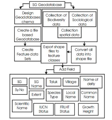
Figure 4. Methodology for Geodatabase Development
Each SG comprises species data along with their scientific names, growth height, threats and conservation status as provided by International Union of Conservation of Nature (IUCN) and Environmental Information System (ENVIS) - Foundation for Revitalisation of Local Health Traditions (FRLHT Database).For the Present work, conservation status of species is determined by using the IUCN Red List Categories and Criteria because, though there are several methods of determining species status, IUCN is commonly used tool, which allows consistency in approach across different taxonomic groups. It helps in determining the relative risk of extinction and provides the basis for understanding if a species is Extinct, threatened (Critically Endangered, Endangered or Vulnerable), Near Threatened, Least Concern, or lacking sufficient basic data for assessment (Data Deficient) [16].
Open Geosuite application is an open source software which can be freely downloaded from http://boundlessgeo.com/solutions/opengeo-suite; which consits of open Geosuite dash board, which is a single interface that allows to access all components of Open Geo Suite, including links to common tasks, configuration, and management. It runs as web application in the same container as GeoServer, accessible at http://localhost: 8080/dashboard. There are load layers i.e, shape files and one can edit the properties and compose and publish web map. Figure 5 represents the Methodology adopted for Open Geosuite applications.
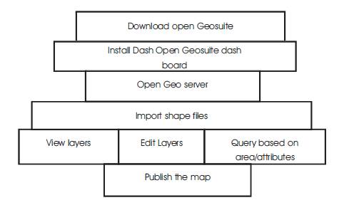
Figure 5. Methodology for OpenGeosuite applications
The present work is carried out aiming to prepare Geodatabase for SGs which are shown in Table 1. Totally 851 flora and fauna were observed/found during the field visit. Out of 851 of the total flora and fauna, 91 varieties of Tree species, 59 varieties of Medicinal plant species, 16 animals and 26 birds species have been recorded. All the attribute data has been brought into Arc GIS Environment and summarised to get the reports from which it was found that SGs are treasure houses of Medicinal plants and Traded Medicinal Plants. It was also found that critically endangered species and vulnerable species were preserved in SGs. The list of Scientific Names of the Species is given and Table 2 shows the conservation status of the identified species.
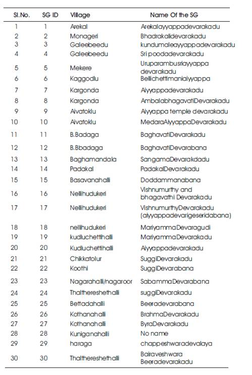
Table 1. Locations of SG of KodaguDist
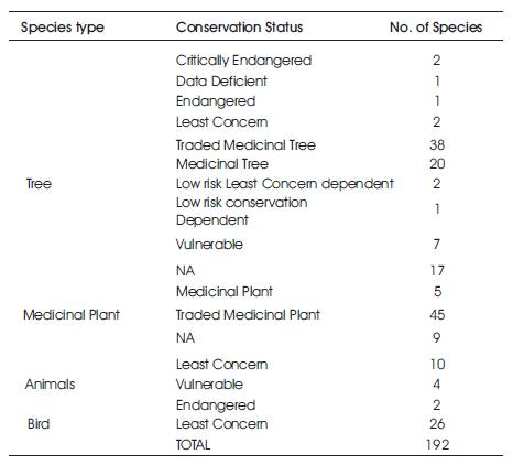
Table 2. Conservation status of species present in SG
Artocarpusintegrifolial, Trema orientalisbl. , Ananascomosus (l.) Merr., Sapinduslaurifoliavahl, Sapindu semarginatusvahl. , Michelianilagirica, Urenalobata l., Dalbergialatifoliaroxb., Iophopetalum wallichii kur z, Schleicheraoleosa (lour.) oken, Plumbagorosea l., Cinnamomum verum pres, Vateriaindica. Nothapodytes nimmoniana (grah.), Hymenodictyon orixense (roxb)., Polyalthiafragrans, Persea macrantha (nees), Artocarpusheterophyllus lam., Calamus thwaitesii becc, Artocarpushirsutus lam., Actinodaphnehookeri, Pterocarpusmarsupiumroxb., Diospyros malabarica (desr.), Terminaliapaniculata roth, Myristica fragrans houtt., Celtis tetrandra roxb, Vernonia cinerealess. ,Myristicada ctyloidesgaertn , Dilleniapentagyna roxb., Jasminumangustifoliumvahl, Plumeriaacuminata r.br., Cassia fistulal., Magnolia champaca l., Sterculiaalata, Buchananialatifoliaroxb., Scolopiacrenata (wt. &arn.) clos, oscinium fenestratum (gaertn.) coleb, Emblicaofficinalisgaertn., Syzygium cumini(l.)skeels ,Wrightiatinctoriar.br. , Phyllanthusdistichus (l.), Mimusopselengi l., Elaeocarpus ganitrus roxb, Magnolia champacal., Acaciasinuata (lour.) merr., Terminaliabellerica (gaertn.) roxb., Litsea floribunda (bl.) gamble, Mallotustetracoccus (roxb.) kurz, Macarangaindica w., Ficusreligiosa l., Ficusreligiosa l., Ficusracemosal., a lebbeck (l.) benth., icustsiela roxb., Aeglearmelos ,Cinnamomumverumpres , Garugapinnataroxb . ,Ficus mysorensis , Sterculiaguttataroxb., Mangiferaindica l., Oleadioica roxb. – oleaceae, Dalbergia latifolia roxb., Acacia caesia (l.) willd., Acrocarpusfraxinifoliuswight&arnolal, Ficus infectoria sensuroxb., Schefflera venulosa (wight), Calophyllum apetalum willd., Boswellia serrata roxb., Zizyphusxylopyrus willd., Artocarpuscommunis j. & g. forst., Plumeria acuminata r.br., Anacardiumoccidentale l., Salvadorapersica l., Alstoniascholaris r.br, Vateriaindica l., Zizyphusxylopyruswilld., Manilkara hexandra (roxb), Haldinacordifolia (roxb.), Holigarnaarnottianahook.f., Ficushispida l.f., Lagenariasiceraria (molina) standley, Canarium strictum roxb., Dilleniapentagynaroxb., Spondias pinnata (l.f.), Lagerstroemia lanceolata wall., Lagerstroemia lanceolata wall. ex. wight&arn., Cedrela toona roxb., Garcinia indica (dup.), Acacia sinuata (lour.) merr., Santalum album l., Terminaliaalataheyne ex roth.,.
Asparagus racemosus willd,Zizyphus oenoplia mil,Sidacordifolia l., Pandanus odoratissimus l.f., Curcuma aromatica salisb,. Callicarpatomentosa (l.) murr., Bauhinia malabarica roxb, Leucas aspera, Bidenspilosa, Calamus rotang l.,Sida acuta burm., Caryotaurens l., Cassia tora l., Solanumtorvumswartz, Myristicamalabarica lam, Entada rheedei spreng, Rhaphidophora pertusa schott, Randiaspinosapoir., Stachytarpheta jamaicensis (l.), Ipomoea pandurata, Triumfetta rhomboidea jacq., Wendlandia exerta d, ocasiaindica (lour.) spach, Ophiorrihza mungos l, Litsea glutinosa (lour.) robinson, Mallotusphilippensis (lam.) muell.-arg., Pongamiaglabra vent, Trichiliaconnaroides, Vernoniaarborea, Solanumtorvumswartz, Cissus pallida (wight&arn.) planchon, Acacia concinna (willd.), Litsea chinensis lam, Caesalpinia pulcherrima, Hibiscus sabdariffa l.,Centella asiatica (l.) urban, Aponogeton natans (l.) engl.&Krause, Bacopa monnieri (l.) Pennell, Ervatamiacoronaria (jacq.) stapf, Mesuanagassarium (burm.f.) kosterm., Mimosa pudica, Remusatia vivipara schott, Tridax procumbens l, Acacia concinna (willd.), Asparagus racemosus willd., Croton oblongifoliusroxb, Solanumtor vum, Leucas aspera (willd.) spreng, Elettariacardamomummaton, Lantana camara l., Bambusaarundinaceawilld., Murraya paniculata (l.) jack, Solanumerianthumd.don, Toddaliaasiatica (l.) lam, Lantana camara l., Solanum xanthocarpum schrad &wendl, Rubia cordifolia l, Lantana camara l., Cinnamomummacrocarpum hook.
Vulpesvulpes,Melursusursinus,Sciurusvulgaris, Hyaenahyaena , .Bosgarus ,Cuonalpines , Macacafascicularis, Elephasmaximusindicus, Sus scrofa ,Herpestesjavanicus, Muntiacusmuntjak, Rusa unicolor, Felissilvestris, Ovisaries, Lepusnigricollis, Hystrixindica.
Duculaaenea, Melanerpesformicivorus, Haliastur Indus, Bubo bubo, Pavocristatus, Tyto alba, Graculareligiosa, Centropussinensis, Ocycerosgriseus, Corvus culminates, Gallus sonneratii, Egrettagarzetta, Psittaculakrameri, Anastomusoscitans, Cuculusvarius, Athenebrama, Centropusbenga lensis Spilopeliachinensis , Dicrurusparadiseus, Megalaimaviridis, Acridotherestristis, Nisaetuscirrhatus, Spilopeliasenegalensis, Psittaula Kramer, Terpsiphoneparadise, Cynopterussphin.
After developing SG Geodatabase, the work aimed at bringing all these data into a system which aids in the dissemination of data through which the biodiversity value SGs hold will be spread and, based on the species availability and threat they face, prioritization for conservation can also be done which is very much needed for conservation action. The Open Geosuite Software was utilized for this purpose. Published data through Open Geo suite will not be helpful for visualization, however, queries can be made based on the location or based on the attributes. Figure 6 shows the Dash board of Open Geosuite, Figure 7 shows the Road network of the district in Geo explorer, Figure 8 shows the Sacred Groves and Figure 9 shows the Query based on Location done by Using Open Geo Explorer.
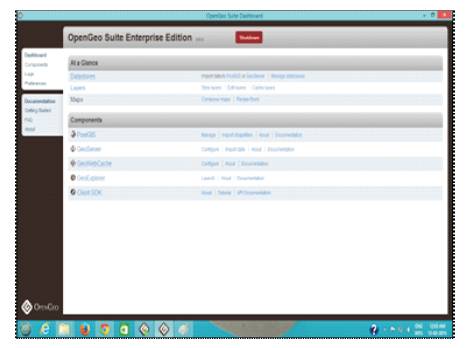
Figure 6. OpenGeosuite Dash Board
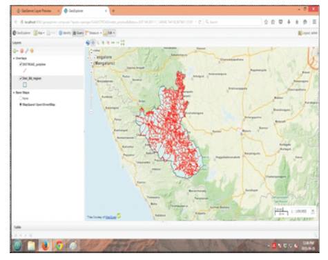
Figure 7. Road network of the District in Geo Explorer
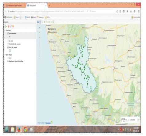
Figure 8. Sacred Groves of Kodagu District in Geo Explorer
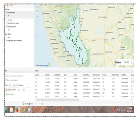
Figure 9. Query of SG based the Location
The present study revealed that out of 150 varieties of Floral species studied, 89 species have been considered as Traded Medicinal Plants/Trees, which clearly depicts the fact that SGs are treasure House of medicinal trees. From the conservation status of the species, it is clear that a technology is needed to understand the strength and fragileness of SG from various perspectives which supports the effective implementation of conservation measures. The Spatial database designed for SG should be made use of, to understand the conservation priority. These SGs are working mainly on the tenets of religious beliefs and these SGs can be preserved in better ways if the local people as well as Public/policy makers are aware of the value and importance of SGs. To spread awareness, the information regarding the biodiversity, social, religious value of these SGs should be made accessible to all in order to preserve these SGs from further depletion.
Much research has been done, that upholds the biodiversity value and towards the need for conservation of SGS , but to conceptualize how to carry out the conservation, comparatively, few studies have been done to solve the crisis of conservation. The study focuses on the basic parameters which are very much needed for conservation of SGs, one is systematic compilation of data in one platform and another is dissemination of the data so that studies and research will not be repeated and will be made on all SGs which have not been studied by anyone. The work also reveals the facts about the presence of totally 108 medicinal flora, 2 critically endangered and 3 endangered and 11 vulnerable species in SGs and this helps to take decisions towards conservation action. Based on the literature survey made, it is evident that in our country the technology of GIS has not been widely used for bringing out the traditional knowledge and scientific knowledge in one platform. It is recommended that more importance should be given for sharing of data with the technical experts/researchers and for building awareness among local community, younger generation and policy makers; which is very much needed for conservation of the SG.