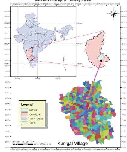
Figure 1. Location Map of Study Area
A study is carried out to determine the crop water requirement of some selected crops for the command area in Kunigal taluk. These crops include rice, pulses, groundnut, sugarcane and millet (ragi). Crop water requirement for each of the crops is determined by using 30-year climatic data in CROPWAT. Reference crop evapotranspiration (ETo) is determined using the FAO Penman Monteith method. For all the crops considered, three decades: decades I, II, and III and seven crop growth stages: nursery, nursery / land preparation, land preparation, initial stage, development stage, mid-season and late season stage are considered. The study shows that for the area under study, reference evapotranspiration (ETo) varied from 3.11 to 5.29 mm/day. Crop evapotranspiration (ETc) and crop water requirement for sugarcane varied from 1.61mm/day to 3.46mm/day and 0.0 mm/dec to 51.9 mm/dec, for ragi (millet) from 1.44 mm/day to 3.46 mm/day and 0.0 mm/dec to 2.6 mm/dec, for groundnut( rabi) from 0.66 mm/day to 4.45 mm/day and 0.0 mm/dec to 43.9 mm/dec, for groundnut (kharif) from 1.78 mm/day to 4.34 mm/day and 0.0 mm/dec to 14.6 mm/dec, for rice from 0.39 mm/day to 4.82 mm/day and 1.5 mm/dec to 184.9 mm/dec, and for pulses from 2.41 mm/day to 4.22 mm/day and 13.2 mm/dec to 38 mm/dec respectively. The gross water requirement is 939.14 mm/year with an application efficiency of 70%. Therefore the entire land area of 6572 ha requires 61.72 MCM. Thus the dam can conveniently supply the water required for irrigation in the area.
Water is important for plant growth and food production. There is competition between municipal, industry users and agriculture for the finite amount of available water. Estimating irrigation water requirements accurately is important for water project planning and management [1]. The primary objective of irrigation is to apply water to maintain crop evapotranspiration (ETA) when precipitation is insufficient. The finite total amount of available water is crucial for the economy, health and welfare of a very large part of the developing world. Hess [2] defined crop water requirements as the total water needed for evapotranspiration, from planting to harvest for a given crop in a specific climate regime, when adequate soil water is maintained by rainfall and/or irrigation so that it does not limit plant growth and crop yield.
Net irrigation water requirements (NIWR) in a specific scheme for a given year is thus the sum of individual Crop Water Requirements (CWRi) calculated for each irrigated crop. Multiple cropping (several cropping periods per year) is thus automatically taken into account by separately computing crop water requirements for each cropping period. By dividing the area of the scheme (S. in ha), a value for irrigation water requirements is obtained and can be expressed in mm or in m3/ha (1 mm = 10 m3/ha). CROPWAT [3] is a practical tool to help agrometeorologists, agronomists and irrigation engineers to carry out standard calculations for evapotranspiration and crop water use studies, and more specifically the design and management of irrigation schemes. It allows the development of recommendations for improved irrigation practices, the planning of irrigation schedules under varying water supply conditions, and the assessment of production under rainfed conditions or deficit irrigation. Broner and Schneekloth [4] reported that water requirements of crops depend mainly on environmental conditions. Plants use water for cooling purposes and the driving force of this process is prevailing weather conditions. Different crops have different water use requirements, under the same weather conditions.
Crops will transpire water at the maximum rate when the soil water is at field capacity. Broner [4] reported that knowing seasonal crop water requirements is crucial for planning crop planting mixture especially during drought years. Adequate data on irrigation water requirements of most crops is not available in developing nations of the world. This is one of the reasons for the failure of large scale irrigation projects in most developing countries of the world. Adeniran K.A et.al. [5] carried out a study to determine the crop water requirement of some selected crops for the area around Kampe (Omi) Dam Irrigation Project. These crops include rice, maize, tomato, vegetable amaranth, pepper, onion and cabbage. The results showed that reference and crop evapotranspiration (ETo and ETc ) were higher for crops with longer growing season than for those with shorter ones. Also ETo and ETc were more during the dry season than the rainy season. Jehanger et al., [6] reported that rice requires more water than those of other crops. Luca et al., [7] and Broner and Schneekloth [4] obtained values in the same range for the water requirement of maize. Saravanan et.al [8] carried out study to determine the water requirement of main crops in the perumal tank irrigation command area in Cuddalore district. The main crops included in their study were rice, groundnut and sugarcane. Their results showed that reference and crop evapotranspiration (ETo and ETc ) were higher for crops with longer growing season than for those with shorter grower season. Also ETo and ETc were more during the summer season than the rainy season. The range of water requirement for lowland rice was particularly high because the water requirement during the peak rainy season (due to large amount of rain water) was very low while that of the peak dry season (no rainfall) was very high. The objective of this study is to determine crop water requirements of rice, pulses, groundnut, sugarcane and millet (ragi).
The study area Kunigal as shown in Figure 1 is situated about 35 km south of Tumkur on the Bangalore-Hassan road, and 75 km from Bangalore city. Kunigal is located at a latitude of 12.45°N and longitude of 76.20°E. It has an average elevation of 726 m. The annual average rainfall of Kunigal is 593.0 mm. Tumkur district falls under agriculture zone 4 (Central dry zone), zone 5(Eastern dry zone) and zone 6 (Southern dry zone). The Zone 4 consists of 6 taluks namely Chikkanayakanahali, Tiptur, Koratagere, Sira, Madhugiri and Pavagada. The Zone 5 consists of Gubbi and Tumakuru taluks and the Zone 6 consists of Kunigal and Turuvekere taluks. The South West monsoon starts normally from 1st week of June and peak precipitation will occur during September.
Figure 1. Location Map of Study Area
Very near to this place at Marconahalli, a dam has been built across the Shimsha River forming the biggest reservoir in the district. Marchonahally Dam, (Markonahalli Reservoir) has been the life-saving water source for irrigating over 6,000 hectares of land spread over villages around Kunigal. It is located around 50 km from Tumkur town. Markonahalli dam is said to be a unique water resource management project as the reservoir has automatic siphon spillways, considered to be an efficient flood control system requiring no manual operations.
Three decades and seven stages of plant growth were used in crop water requirement determination. The decades include I, II and III while the crop growth stages include nurser y, nurser y/land preparation, land preparation, initial stage, development stage, midseason stage and late season stage.
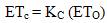
The term crop water requirement is defined as the amount of water required to compensate the evapotranspiration loss from the cropped field. Although the values for crop evapotranspiration and crop water requirement are identical, crop water requirement refers to the amount of water that needs to be supplied, while crop evapotranspiration refers to the amount of water that is lost through evapotranspiration. The crop ET (ETc ) is estimated by FAO Penman-Monteith equation [9,10]
where the reference crop ET (mm/day) is as defined in eqn (2) below as:

Where,
Et0 = reference evapotranspiration [mm day- 1],
Rn = net radiation at the crop surface [MJ m-2 day-1],
G = soil heat flux density [MJ m-2 day-1 ],
T = mean daily air temperature at 2 m height [°C],
u2 = wind speed at 2 m height [ms-1 ],
es = saturation vapour pressure [kPa],
ea = actual vapour pressure [kPa],
es - ea = saturation vapour pressure deficit [kPa],
D = slope vapour pressure curve [kPa °C-1 ],
g =psychrometric constant [kPa°C-1 ].
The CROPWAT programme (version 5.7) developed for the FAO Penman-Monteith method (FAO, 2005) is utilized for estimating the crop water requirement of each of the crops studied. To ensure the integrity of computations, the weather measurements are made at 2 m (or converted to that height) above an extensive surface of green grass, shading the ground. The climatic data used for the calculations are obtained from a meteorological station located at Kunigal.
Major types of soils occurring in the district are 1) Red loamy soil, 2) Red sandy soil and 3) Mixed red and black soils. Red loamy soil occurs in eastern central part of the district covering Koratgere, Tumkur, and eastern parts of Madhugiri and Kunigal Taluks. Red Sandy soil covers rest of the area except very small area in the northwestern part of C.N. Halli Taluk where Mixed Red and Black soils occur. Red soils have good drainage but are poor in lime and bases.
The results obtained, when a 30-year period was used with the FAO-Penman Monteith method to determine the reference crop evapotranspiration (ETo) for the area under study show that, ETo varied from a minimum value of 3.11 mm/day in November to the highest value of 5.29 mm/day in June (Table 1). The effective rainfall calculation for the region is carried out by USDA S.C.method using CROPWAT and is shown in Table 2.
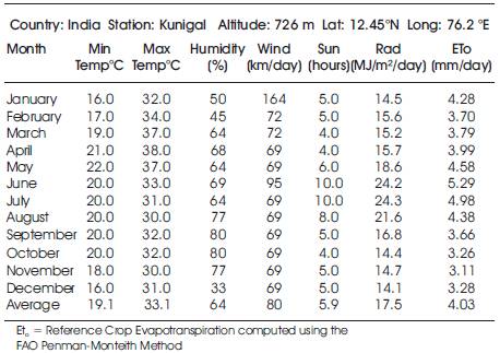
Table 1. Reference Crop Evapotranspiration
Table 2. Effective Rainfall
Results show that for sugarcane, crop evapotranspiration (ETc) and the crop water requirement varied from 1.61mm/day to 3.46mm/day and 0.0 mm/dec to 51.9 mm/dec respectively (Table 3). For Ragi (Millet), crop evapotranspiration (ETc) and the crop water requirement varied from 1.44 mm/day to 3.46 mm/day and 0.0 mm/dec to 2.6 mm/dec respectively (Table 4). For Groundnut( Rabi), crop evapotranspiration (ETc) and the crop water requirement varied from 0.66 mm/day to 4.45 mm/day and 0.0 mm/dec to 43.9 mm/dec respectively (Table 5). For groundnut (Kharif), crop evapotranspiration (ETc) and the crop water requirement varied from 1.78 mm/day to 4.34 mm/day and 0.0 mm/dec to 14.6 mm/dec respectively (Table 6). For rice, crop evapotranspiration (ETc) and the crop water requirement varied from 0.39 mm/day to 4.82 mm/day and 1.5 mm/dec to 184.9 mm/dec respectively (Table 7). For pulses, crop evapotranspiration (ETc) and the crop water requirement varied from 2.41 mm/day to 4.22 mm/day and 13.2 mm/dec to 38 mm/dec respectively (Table 8).
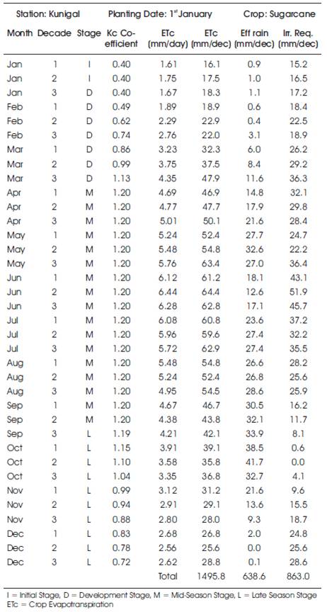
Table 3. Evapotranspiration and Irrigation Requirement for Sugarcane
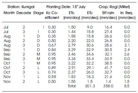
Table 4. Evapotranspiration and Irrigation Requirement for Ragi (Millet)
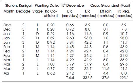
Table 5. Evapotranspiration and Irrigation Requirement for Groundnut (Rabi)
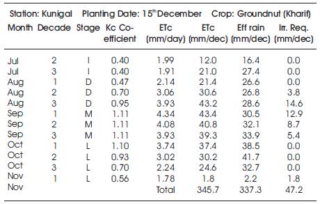
Table 6. Evapotranspiration and Irrigation Requirement for Groundnut (Kharif)
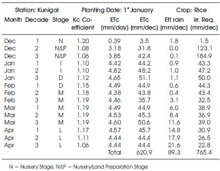
Table 7. Evapotranspiration and Irrigation Requirement for Rice
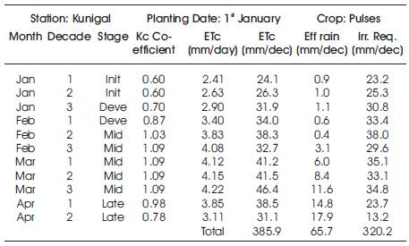
Table 8. Evapotranspiration and Irrigation Requirement for Pulses
The estimation of actual irrigation requirement of Kunigal command area is carried out as shown in Table 9. The net irrigation water requirement is 657.4 mm/year (Table 9). This is summation of the NIR2 values from January to December. Using an irrigation application frequency of 70%, the gross water requirement of 939.14 mm/year is obtained. Therefore the entire land area of 6572ha requires 61.72 MCM. The reservoir capacity is 68 MCM. Thus the capacity of 68 MCM is sufficient to irrigate the irrigation water requirement for the entire area under the Kunigal command area, which is 61.72 MCM. The results show that the dam can conveniently supply the water required for irrigation in the area.
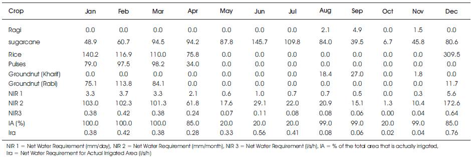
Table 9. Irrigation scheming
The study is carried out to determine the crop water requirement of some selected crops for the command area in Kunigal taluk. These crops include rice, pulses, groundnut, sugarcane and millet (ragi). The following conclusions can be made: